We’ve got a fairly nice week coming up across the region without any extremes of temperature or precipitation.
Weather should be great for the runners of today’s Boston Marathon with a seabreeze near the finish line. Image provided by the Boston Athletic Association.
We start the week off with high pressure in control, giving us lighter winds than Sunday. This will result in a seabreeze keeping coastal areas much cooler than areas farther inland. We’ll also have increasing and thickening clouds as another storm system heads into the Great Lakes. A warm front ahead of the storm will move through tonight, producing a few showers. This sets up a mild Tuesday, before a cold front moves through at night with another shower or two possible. High pressure then builds back in with dry and seasonably mild conditions for Wednesday and Thursday. We’ll turn warmer again on Friday ahead of the next storm system. That system brings in some rain for Friday night and Saturday, then high pressure returns with dry and cooler weather on Sunday.
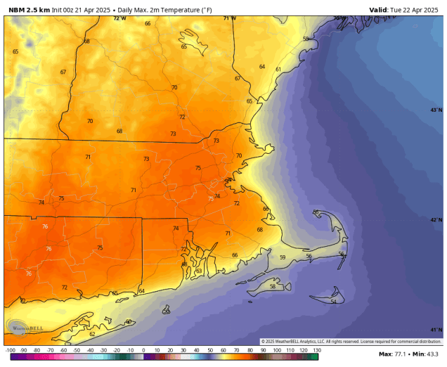
Tuesday looks like the pick of the week with temperatures above 70 away from the coastline. Image provided by WeatherBell,
Monday: Morning sunshine fades behind increasing and thickening afternoon clouds. High 51-58 along the coast, 59-66 inland.
Monday night: Mostly cloudy with a few showers, mainly after midnight. Low 42-49, temperatures may start to rise a little after midnight.
Tuesday: Becoming partly sunny. High 68-75, cooler across the South Coast and Cape Cod.
Tuesday night: Partly cloudy. Low 41-48.
Wednesday: Partly to mostly sunny. High 62-69, cooler across Cape Cod.
Wednesday night: Clear to partly cloudy. Low 39-46.
Thursday: A mix of sun and clouds. High 57-64 along the coast, 65-72 inland.
Thursday night: Partly cloudy. Low 42-49.
Friday: Partly sunny, showers develop late at night. High 66-73, cooler along the coast.
Saturday: Mostly cloudy and breezy with some rain likely. High 60-67, cooler across Cape Cod.
Sunday: A mix of sun and clouds, breezy. High 54-61, cooler across Cape Cod.
Some warmer weather is on the way, but it won’t last too long.
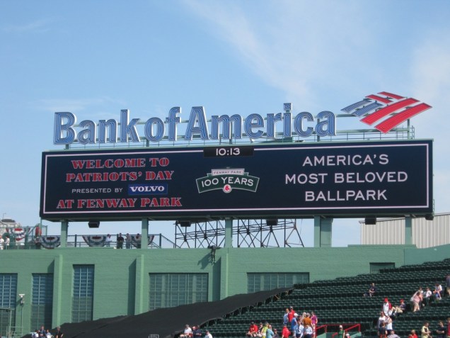
We’ve got some great weather for baseball on tap for Monday morning.
High pressure remains in control into Friday with clear skies and seasonably cool temperatures tonight. We’ll start to warm up a bit on Friday, but also see clouds move in ahead of a weak upper-level disturbance and a warm front. The upper-level disturbance may produce a late-day shower across parts of southern New Hampshire and northern Massachusetts, but most of us will still dry. Low pressure heading into the Great Lakes will send a warm front our way Friday night, with a better chance for showers across the region. Behind the front, we’ll have a significant warmup on Saturday, with many locations away from the South Coast topping 70, but southwest to south winds will keep the South Coast and Cape Cod in the 60s or even 50s, as water temperatures remain rather chilly. Across inland locations, if we get enough sunny breaks, some places may even break 80. A cold front moves through late in the day, possibly producing a few more showers. High pressure builds in behind the front for Easter Sunday with breezy and cooler weather, but many locations will still top 60. For Patriots Day on Monday, we’ll see clouds moving back in with some showers by evening as another system approaches, but again we should top 60, cooler along the coast thanks to seabreezes.
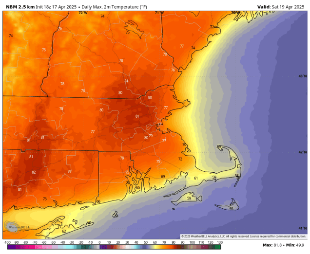
Saturday is shaping up to be a very warm day. Image provided by WeatherBell.
Thursday night: Clear skies. Low 33-40.
Friday: Morning sunshine, then increasing and thickening clouds in the afternoon, slight chance for a late-day shower from the Merrimack Valley northward, becoming breezy. High 60-67, except 52-59 along the South Coast and Cape Cod.
Friday night: Mostly cloudy and breezy with scattered showers. Low 47-54, temperatures may start to rise after midnight.
Saturday: Clouds and some sunny breaks, slight chance for a late-day shower, breezy. High 74-81 inland, 66-73 near the South Coast, 58-65 across Cape Cod.
Saturday night: Mostly cloudy with a few showers during the evening, skies start to clear out late night. Low 48-55.
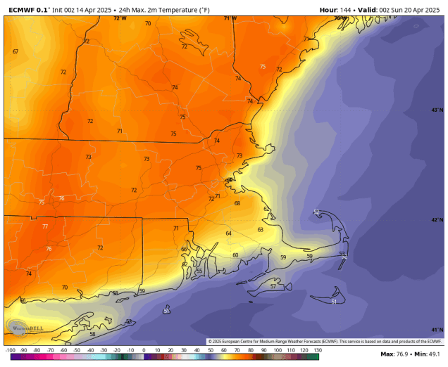
Sunday: Sunshine and a few clouds, breezy. High 58-65.
Sunday night: Partly cloudy. Low 35-42.
Monday: Morning sun, then increasing clouds, showers possibly towards evening. High 55-62 except 47-54 along the immediate coast and across Cape Cod.
There’s no snow in the forecast this week, but there is some milder temperatures.
As far as we’re concerned, Patriots Day is the best day of the year and it’s only 1 week away. Image provided by the New York Times.
We start the week off with a sunny and mild day as high pressure builds in, but it won’t last long. Low pressure moving into the Great Lakes will send a warm front our way, sending clouds in this evening, with a few showers likely overnight. Tuesday will feature plenty of clouds and a few breaks of sun, but also some mild temperatures ahead of a cold front. That front may produce a shower or two during the afternoon, but otherwise we should remain dry, however, temperatures may quickly drop late in the day behind the front. High pressure then builds in with drier and cooler conditions for Wednesday and Thursday. As that high moves off to the east on Friday temperatures will start to moderate, but we’ll also see more clouds moving in. Saturday could be a very warm day, with temperatures potentially topping 70 in many areas, but we’ll also have lots of clouds and likely some showers as a cold front moves in. We’ll clear out behind the front and turn cooler again on Sunday, with some moderation expected for Patriots Day on Monday.
Saturday has the potential to be a very mild day. Image provided by WeatherBell.
Monday: Plenty of sunshine, clouds start to filter in late in the day. High 59-66, cooler across Cape Cod.
Monday night: Becoming mostly cloudy, a few showers likely after midnight. Low 40-47.
Tuesday: Morning clouds, then becoming partly sunny, slight chance for an afternoon shower. High 59-66, cooler across Cape Cod.
Tuesday night: Clear to partly cloudy. Low 35-42.
Wednesday: Partly sunny, breezy, and cooler. High 46-53.
Wednesday night: Becoming clear. Low 33-40.
Thursday: Sunshine and a few clouds, breezy. High 51-58.
Thursday night: Clear skies, a few late-night clouds. Low 32-39.
Friday: Morning sunshine gives way to increasing afternoon clouds, some showers possible at night. High 55-62, cooler across Cape Cod.
Saturday: Mostly cloudy, breezy, and mild, with scattered showers likely, favoring the morning and again late in the day. High 63-70, cooler across the South Coast and Cape Cod.
Sunday: Partly to mostly sunny, breezy, and cooler. High 53-60.
Patriots Day: A mix of sun and clouds. High 56-63, cooler across Cape Cod.
Another dreary weekend is on the way for the region, and there may even be some snow for parts of the region.
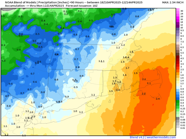
Some much-needed rain is on the way for the weekend. Image provided by Weathermodels.com
Low pressure will head toward the Mid-Atlantic states tonight, sending some showers our way. Across the interior, well north and west of Boston, temperatures will be marginally cold enough for the rain to change to snow, especially in the hills of Worcester County and the Monadnocks, but also some of the lower elevations outside of I-495. We’re not expecting any accumulation, though it wouldn’t be a shock if there was a coating on some grassy surfaces. The showers should taper off towards daybreak. and Friday will just be a cloudy day with a few stray showers possible. The low over the Mid-Atlantic states starts moving our way Friday night, with some steadier and heavier rain moving in, and continuing for much of Saturday. Again, we’ll have some marginally cold air in place Friday night, so we could see more snow mixing in, with a coating possible on grassy surfaces outside of 495, and possibly a little more than that in the hills of Worcester County and the Monadnocks once again. Saturday will be a rather chilly day with northeast winds keeping temperatures in the upper 30s and lower 40s for much of the region. Combine that with the rain, and it won’t be a great day to be outside. The rain tapers off Saturday night, but as that system starts moving toward the northeast and passes offshore, it could possibly bring in some more rain on Sunday, especially for eastern Massachusetts and Rhode Island. That system pulls away Sunday night and high pressure briefly builds in for Monday with some sunshine and milder conditions.
Accumulating snow should be confined to the hills, but there could be a coating on grassy surfaces across the interior. Image provided by WeatherBell.
Thursday night: Cloudy with some showers developing, possibly mixed with snow across the interior. Low 32-39.
Friday: Cloudy and becoming breezy with a few showers possibly, mainly in the morning. High 43-50, coolest along the coast.
Friday night: Cloudy and breezy with rain developing, mixed with snow across the interior. Low 31-38.
Saturday: Breezy with periods of rain. High 37-44.
Saturday night: Rain tapers off the showers. Low 33-40.
Sunday: Cloudy and breezy with more showers possible, favoring eastern Massachusetts and Rhode Island. High 44-51, coolest across southeastern Massachusetts and Cape Cod.
Sunday night: Any showers end in the evening, becoming partly cloudy overnight. Low 34-41.
Monday: Partly sunny. High 56-63, cooler across Cape Cod.
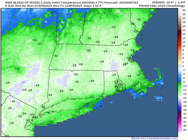
Remember how great Friday was with sunshine and temperatures near or above 70? Yeah, there aren’t any days like that in this week’s forecast.
Temperatures will be 10-15 degrees below normal for much of the upcoming week. Image provided by Weathermodels.com
A frontal system is stalled out south of New England this morning and a wave of low pressure will ride along it, bringing us some precipitation. With enough cold air in place, we’ll see the precipitation start as snow this morning, mainly from the Mass Pike northward, eventually changing over to rain. With the high sun angle, and warmer ground, we’re not expecting any accumulation, except maybe in the hills of Worcester County and into the Monadnocks. Otherwise, it’s just a chilly rain today, gradually ending tonight as a cold front moves through, possibly allowing the rain to change to snow before ending. A few rain or snow showers are possible Tuesday, otherwise, drier and chillier conditions are expected for Tuesday into Wednesday with high pressure building in. Temperatures start to moderate on Thursday as the high moves offshore, but clouds will move in ahead of another system moving out of the nation’s mid-section. This will bring us some more rain Thursday night into Friday. Another slow-moving system follows for the weekend with more rain.
For now, Saturday is looking wet. Images provided by Pivotal Weather.
Monday: Cloudy with snow developing north of the Mass Pike, changing to rain during the afternoon, rain likely south of the Pike, possibly mixed with snow at the start. High 38-45.
Monday night: Cloudy with a few rain or snow showers. Low 30-37.
Tuesday: Any lingering rain or snow showers end in the morning, becoming partly sunny and breezy in the afternoon. High 39-46 early, temperatures may drop in the afternoon.
Tuesday night: Clear skies. Low 23-30.
Wednesday: Sunshine and a few clouds. High 40-47.
Wednesday night: Clear during the evening, becoming partly cloudy overnight. Low 25-32.
Thursday: Becoming mostly cloudy with showers possible late in the day. High 47-54.
Thursday night: Cloudy with a chance of showers, possibly mixed with wet snow in southern New Hampshire. Low 35-42.
Friday: Mostly cloudy with a chance of showers early, then becoming more likely by evening. High 50-57.
Saturday: Mostly cloudy with rain likely. High 48-55.
Sunday: More clouds than sun with additional rain possible. High 49-56
The weather looks fantastic for the Red Sox home opener at Fenway tomorrow, but the rest of the weekend doesn’t look that great.
The home opener at Fenway means summer isn’t far away.
A cold front will cross the region this evening, possibly accompanied by a few showers tonight. The front settles south of New England on Friday, with some clearing taking place from north to south. Temperatures will remain mild, which is good news if you’re heading to Opening Day at Fenway. For first pitch at 2:10pm, skies will be partly sunny, winds out of the northwest at 10-15 mph (blowing from left field to right field), and the temperature will likely be in the lower 60s. Clouds will start to stream back in late Friday night as that frontal system starts lifting northward once again. Saturday is looking like a rather cool day with northeast to east winds off the ocean, and rain developing toward midday. Occasional periods of rain and showers are likely into the nighttime hours before tapering off. The front will lift through as a warm front on Sunday, but how far north it gets is still a question mark. Areas south of Boston should have a very mild afternoon, but how warm it gets north of Boston, especially into southern New Hampshire, is uncertain. If the warm front does get that far north, temperatures could get well into the 60s. If not, it could stay in the 50s or even upper 40s all afternoon. We’ll have some spotty showers at times, but the day shouldn’t be a washout. Another low pressure area moves through later in the day and at night with more rain likely. That system drags a cold front through at night, with cooler air moving in behind the system on Monday. Showers should gradually end during the day as the system moves offshore.
Sunday’s temperatures are dependent on the northward progress of a warm front. Images provided by Pivotal Weather.
Thursday night: Mostly cloudy with a few showers possible, mainly south of the Mass Pike. Low 46-53.
Friday: Any lingering showers near the South Coast end early, followed by gradual clearing from north to south. High 58-65.
Friday night: Partly cloudy through the evening, clouds increase and thicken up after midnight. Low 35-42.
Saturday: Mostly cloudy and cooler with rain developing. High 41-48, temperatures may drop a little in the afternoon.
Saturday night: Rain tapers off to showers. Low 35-42, temperatures may start to rise after midnight.
Sunday: Plenty of clouds with a few showers possible. High 55-62, possibly warmer south of Boston.
Sunday night: Cloudy with more rain and showers. Low 36-43.
Monday: Mostly cloudy, showers ending. High 44-51.
Temperatures will be up and down this week as a couple of systems impact the region, but the weather looks great for the Red Sox home opener at Fenway on Friday.
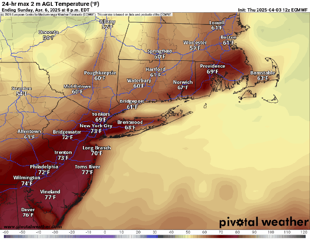
With a little sun temperatures could get very warm this afternoon. Image provided by WeatherBell.
The week starts off with low pressure moving into the St. Lawrence Valley dragging a warm front across the region this morning, resulting in a rather mild day, except near the South Coast, where southerly winds blowing off the still-chilly Atlantic will keep things cooler. Cloudcover will keep temperatures in the 60s away from the South Coast, but if any sunny breaks develop, we could see temperatures jump into the lower 70s inland. A few showers are possible during the day, but they’ll become more widespread by evening as a cold front approaches from the west. Rain is likely during the evening and first part of the night, with some thunderstorms possible as well, before the cold front crosses the region, bringing an end to the rain. High pressure builds in for Tuesday, with clearing skies accompanied by breezy and much cooler conditions. High pressure remains in control for the start of the day Wednesday, but clouds will quickly stream back in during the day, as a low pressure system moving into the Midwest sends a warm front our way. We’ll see showers developing ahead of the warm front Wednesday night, but across southern New Hampshire and possibly the Merrimack Valley, there may be just enough cold air in place when the precipitation moves in for some snow or sleet at the start, but we’re not expecting any accumulation. Thursday looks like another mild day with some showers possible as another cold front moves through. That front will stall out just south of New England, allowing high pressure to build in for Friday. A wave of low pressure rides along the front on Saturday, bringing clouds back in, with some showers across southern portions of the region, especially late in the day and at night. Another wave will bring in more rain on Sunday, but temperatures will be dependent on whether the front remains to our south, or that wave lifts it back northward as a warm front.
Sunday is shaping up to be another rainy day across the region. Images provided by Pivotal Weather.
The Red Sox open their home schedule at Fenway on Friday against the St. Louis Cardinals with first pitch scheduled for 2:05pm. Weather shouldn’t be an issue. Skies should be partly to mostly cloudy, winds out of the northwest at 5-10 mph, and temperatures likely near or above 60 degrees. For early April, you couldn’t ask for better baseball weather around here.
The home opener at Fenway means summer isn’t far away.
Monday: Lots of clouds and possibly a few sunny breaks, a few showers also possible, breezy, and milder. High 63-70, cooler along the South Coast and Cape Cod.
Monday night: Cloudy with rain and thunderstorms developing, ending before daybreak. Low 39-46.
Tuesday: Early clouds and a few lingering showers, mainly across Cape Cod, then becoming partly to mostly sunny in the afternoon, breezy, and cooler. High 47-54.
Tuesday night: Clear skies, some clouds may start to move back in late at night. Low 25-32.
Wednesday: Morning sun, then increasing afternoon clouds. High 41-48.
Wednesday night: Cloudy with showers developing, mainly north of the Mass Pike, possibly mixed with a little snow or sleet in southern New Hampshire. Low 31-38, temperatures may start rising after midnight.
Thursday: Cloudy, breezy, and milder with scattered showers. High 58-65, cooler along the South Coast and Cape Cod.
Thursday night: Mostly cloudy with periods of rain and showers, ending late at night. Low 48-55.
Friday: Morning clouds, some clearing in the afternoon. High 60-67, cooler across Cape Cod.
Saturday: Partly to mostly cloudy with a chance for some showers, mainly late in the day and at night, favoring areas south of the Mass Pike. High 44-51.
Sunday: Mostly cloudy with a chance of rain. High 47-54.
Opening Day has arrived, our surest sign of Spring yet. However, Mother Nature will remind us this weekend that Spring doesn’t always feature nice weather around here.
The Red Sox begin their 2025 season this afternoon in Arlington, TX. Image provided by mlb.com
A weak frontal system will cross the region tonight with just a few rain or snow showers accompanying it, but it will have a much bigger impact on the region over the weekend. That front will stall out right across the region on Friday, which should end up being a decent day with some sunshine and seasonably cool temperatures. Waves of low pressure will ride along the front over the weekend, bringing in episodes of rain, possibly starting as a little snow or freezing rain across parts of southern New Hampshire or even the Merrimack Valley. The entire day won’t be a washout, but it won’t exaclty be a nice day either. With the front stalled out, we will have quite the temperature contrast across the region. South of the front, likely across Connecticut, southwest winds will send temperatures well into the 60s or even 70s on Saturday despite the cloudcover. On the other side of the front northeast winds off the still-chilly Atlantic will mean temperatures only in the upper 30s and 40s on Saturday with some occasional showers and drizzle. In between? Well, it depends on where the front stalls, as there will be a difference of 30 or more degrees over a span of 30 or so miles. That front will sag southward on Sunday, bringing the cooler air into Connecticut as well, with episodes of showers likely across the region. As stronger low pressure area heads toward the St. Lawrence Valley Sunday night, it will lift the front back across the entire region as a warm front, resulting in a milder day on Monday for the entire region, but with more showers likely. A cold front finally moves through late Monday, bringing an end to the rain.
How far north does the warm air get on Saturday? The models all have different ideas. Images provided by Pivotal Weather.
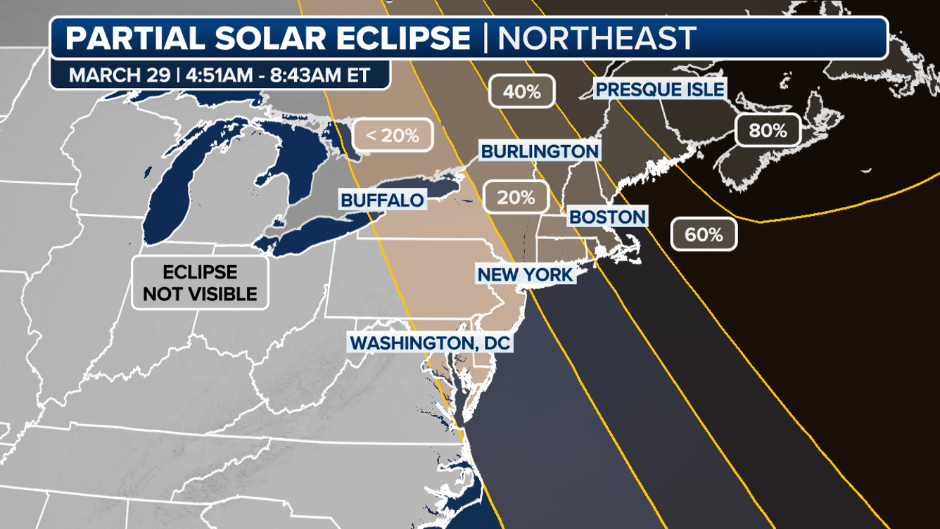
With the clouds expected early Saturday, our chances of seeing the sunrise partial eclipse of the sun are pretty slim, but there’s still a chance that we’ll have just enough clear skies on the eastern horizon to be able to see it.
A partial solar eclipse may be visible at sunrise Saturday morning. Image provided by Fox Weather.
Thursday night: Becoming partly to mostly cloudy, slight chance for a rain or snow shower. Low 30-37.
Friday: A mix of sun and clouds, breezy. High 50-57.
Friday night: Becoming mostly cloudy with showers developing, possibly as some snow or sleet across southern and central New Hampshire. Low 33-40.
Saturday: Plenty of clouds, some sunny breaks possible, mainly near the South Coast. Some showers and drizzle are possible at times, especially near the east coast. High 35-42 across southern New Hampshire and central and eastern Massachusetts north of the Mass Pike, and also along eastern coastal sections, 43-50 across interior southeastern Massachusetts and Rhode Island, possibly even warmer, especially in southwestern Rhode Island. Temperatures may drop during the afternoon along the coast and into southern New Hampshire.
Saturday night: Cloudy with more showers, possibly some freezing rain across central and southern New Hampshire. Low 31-38.
Sunday: Cloudy with scattered showers. High 38-45, a little cooler across southern New Hampshire.
Sunday night: Cloudy with a few more showers. Low 35-42 during the evening, temperatures rise overnight.
Monday: Mostly cloudy, breezy, more showers likely, possibly some steadier rain or even a rumble of thunder in the afternoon. High 57-64, cooler across the South Coast and Cape Cod.
The last full week of March will be a reminder that although it’s now Spring, it won’t always feel that way.
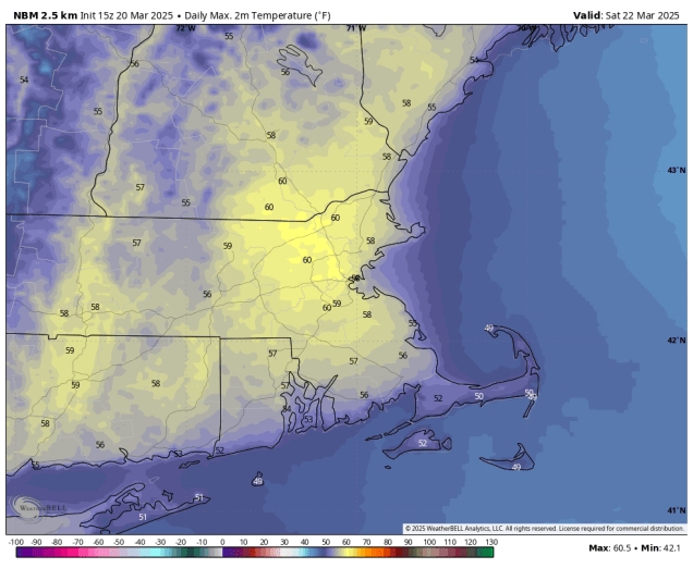
High temperatures are normally close to 50 in late March. Image provided by Weathermodels.com
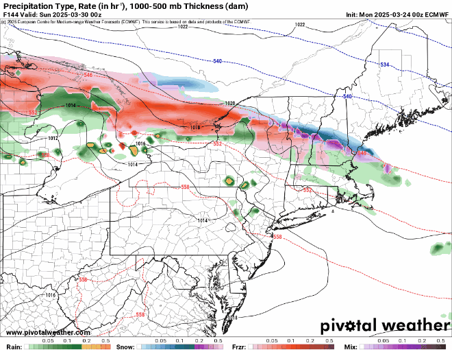
The week starts off with a low pressure system heading across the Great Lakes, sending some rain in for much of the day. However, in the morning, we’ll have just enough cold air in place for some snow, mainly well north and west of Boston, but there won’t be much, if any, accumulation before the change to rain, except possibly in the Worcester Hills and the Monadnocks. That system pulls away, and an upper-level low moves in for Tuesday, resulting in a cool day with clouds, and possibly a sprinkle. Another system will pass by to the south Tuesday night and Wednesday, generating some rain across Cape Cod and southeastern Massachusetts, and possibly a fit farther north and west. There could even be enough cool air in place that if the rain penetrates far enough inland it could change to snow. This is something we’ll be watching over the next day or two. High pressure builds in for Thursday with a sunny and cool day. Another cold front moves in on Friday with a few showers. The weekend looks unsettled at the moment, but full of questions marks. Another low pressure system will head into the Great Lakes, with a warm front extending eastward from it. Ahead of that front we’ll see some precipitation on Saturday, but whether it is rain or snow changing to rain remains to be seen. If the warm front moves through, then, Sunday could be a mild day, but with a cold front moving in from the west, we could see more rain showers before the day is done. If the warm front doesn’t move through, then it will be quite a bit cooler, with the potential for more rain as a wave of low pressure rides along the front to our south.
We could have some snow, rain, or both this weekend as a storm system moves in. Images provided by Pivotal Weather.
The Saturday morning forecast is of interest for another reason. We will have a partial solar eclipse at sunrise Saturday (around 6:30am), so we’re hoping for clear skies, at least on the eastern horizon. The eclipse will actually reach its maximum before sunrise, but as the sun comes up, it will be 50-70% covered by the moon until the eclipse ends just after 7:00am. We’ll keep an eye on this as the week goes on, but right now, hope for some clear skies and set your alarm to get up early on Saturday for another rare celestial event.
A partial solar eclipse may be visible at sunrise Saturday morning. Image provided by Fox Weather.
Monday: Cloudy with light rain likely, possibly some morning snow across southern New Hampshire and the Worcester Hills. High 44-51 south of the Mass Pike, 36-43 north of the Pike.
Monday night: Any lingering showers end in the evening, becoming partly cloudy overnight. Low 31-38.
Tuesday: Partly sunny, breezy, chance for a sprinkle. High 47-54.
Tuesday night: Partly cloudy. Low 29-36.
Wednesday: Partly to mostly cloudy, chance for rain across southeastern Massachusetts and Cape Cod, possibly some rain or snow farther inland. High 41-48.
Wednesday night: Clearing. Low 25-32.
Thursday: Sunshine and some afternoon clouds. High 42-49.
Thursday night: Partly cloudy. Low 29-36.
Friday: Partly sunny, breezy, chance for a few showers, mainly early. High 47-54.
Saturday: Partly to mostly cloudy with a chance of rain or snow. High 40-47.
Spring began this morning, but that doesn’t mean it’s time to put your winter gear away.
Saturday is shaping up to be the nicest and mildest day of the weekend. Image provided by WeatherBell.
A cold front is making its way toward the region this afternoon, and we’ll see some rain developing ahead of that front tonight. Rain will continue overnight, ending Friday morning as the front moves across the region. We’ll clear out quickly Friday afternoon, with gusty northwest winds ushering some cooler air into the region. High pressure then builds in for Saturday with a milder day, but we’ll see clouds quickly returning ahead of a weak cold front. That front may produce a couple of showers late Saturday afternoon or evening, but most of us will remain dry. Behind it, colder air moves back in for Saturday night and Sunday, despite clear skies. Clouds move right back in Sunday evening, as another system quickly heads our way. This system is a little more complicated. While we’re looking at a chilly, wet day on Monday for much of the region, there may be just enough cold air in place for the rain to start as snow, mainly well north and west of Boston. If it starts before daybreak, we could even see a little accumulation in spots, mainly southern New Hampshire. Any snow should change over to rain during the morning, with periods of rain and showers likely for much of the day.
Could there be a little snow for parts of the region Monday morning? Images provided by Pivotal Weather.
Thursday night: Mostly cloudy with areas of fog, rain developing after midnight. Low 37-44.
Friday: Showers end in the morning, skies start to clear out from west to east in the afternoon, becoming breezy. High 43-50.
Friday night: Clear skies with diminishing winds, some clouds may start to move back in towards daybreak. Low 31-38.
Saturday: Partly sunny, breezy, just a very slight chance for a late-day shower. High 53-60.
Saturday night: Becoming clear. Low 23-30.
Sunday: Mostly sunny, breezy, clouds start to return by evening. High 40-47.
Sunday night: Becoming mostly cloudy, chance for rain towards daybreak, possibly starting as wet snow well north and west of Boston. Low 27-34, temperatures start rising after midnight.
Monday: Mostly cloudy with rain likely, possibly some wet snow early in the day across southern New Hampshire. High 43-50.