Stop us if you’ve heard this before, but there’s some rain on the way for part of the weekend.
Rainfall has been above normal across the region for most of climatological Spring. Image provided by weathermodels.com
A weak low pressure area pulls away from the region tonight, taking any lingering showers with it. Friday looks like a decent day with some sunshine and warm temperatures, but a weak disturbance moving across the region could produce a shower or thunderstorm during the afternoon. After that, we turn our attention to an area of low pressure heading this way from the southwest. It will bring in some rain for Friday night and Saturday morning, some of which could be heavy, though it looks like the heaviest rain will stay just west of our area. We get into a bit of a lull Saturday afternoon, then another disturbance brings in more showers and possible some thunderstorms Saturday evening and night. High pressure starts to build in on Sunday with drier and cooler weather, but with an upper-level low also moving in, we’ll see some clouds and possibly a popup shower or two. Monday should be the nicest day of this stretch, with mostly sunny skies and temperatures running a little below normal for this time of year.
Most of the models are depicting some heavy rainfall totals for parts of New England this weekend. Images provided by Pivotal Weather.
Sunday marks not only the beginning of climatological summer, but also the start of hurricane season. While there’s nothing imminent, we did take a look at what to expect this season and explained how extremely overdue we are for a storm to head towards New England and our annual start of hurricane season post that was published yesterday.
Thursday night: Partly to mostly cloudy, any lingering showers end in the evening. Low 51-58.
Friday: Becoming partly sunny, chance for an afternoon shower or thunderstorm. High 69-76, cooler along the South Coast and Cape Cod.
Friday night: Mostly cloudy with rain developing, possibly heavy overnight. Low 52-59.
Saturday: Rain tapers off in the morning, some sunny breaks may develop in the afternoon. High 64-71.
Saturday night: Mostly cloudy with another round of showers and thunderstorms, ending overnight. Low 47-54.
Sunday: A mix of sun and clouds, slight chance for a shower, breezy. High 61-68.
Sunday night: Clear to partly cloudy. Low 45-52.
Monday: Sunshine and some afternoon clouds. High 65-72.
Atlantic hurricane season officially starts on Sunday June 1 and runs through November 30, and indications are that it shouldn’t be as active as last year.
List of names for storms that form during the 2025 Hurricane Season. Image provided by NOAA.
The 2024 season was an above normal season by the numbers, with 18 named storms, 11 hurricanes, and 5 major hurricanes. The season got off to a slower start than recent years, with only 3 storms through the beginning of August, and 5 through Labor Day, but 8 named storms formed in a 4 week span between September 9 and October 5. Hurricane Helene made the most headlines, hitting the Big Bend region of Florida area as a Category 4 hurricane on September 27, producing catastrophic wind damage and flooding in parts of the Carolinas. Hurricane Milton was the strongest storm of the season, reaching Category 5 intensity. The estimated minimum pressure in the storm of 895mb tied it with 2005’s Hurricane Rita for the 4th lowest pressure in the Atlantic Basin. Milton made landfall near Siesta Key, Florida on October 9 as a Category 3 hurricane. The other storms to make landfall in the US were Hurricane Beryl in central Texas on July 8, Hurricane Debby which hit the Florida Big Bend on August 5, and Hurricane Francine, which hit Louisiana on September 11. The 5 US hurricane landfalls is the most since 2020, when 6 hurricanes struck the United States. That year also featured 2 major hurricane landfalls, just like 2024. In 2021, a total of 8 tropical systems made landfall in the United States, but only 2 at hurricane strength. That includes 2 tropical storms that made landfall in New England that summer – Elsa and Henri. Both Elsa and Henri each made landfall near Westerly, Rhode Island about 6 weeks apart. This was just the 5th time since 1851 that two tropical systems made landfall in Southern New England or Long Island in the same year, and only the 2nd time (1961 being the other), that both storms were only tropical storm strength. (We’ll have more info on New England tropical systems a little later in this post).
2024 was another active hurricane season. Image provided by the National Hurricane Center.
Forecasts for the upcoming season are calling for a season that features near to above normal activity, though conditions are not nearly as favorable as they were at this time last year. Sea surface temperatures in the Atlantic are considerably cooler, especially in the Main Development Region. In terms of ENSO, last year’s La Nina has faded and we are now in a neutral phase, which is not as favorable for storm development. NOAA issued their seasonal hurricane outlook on May 22, and it calls for a 60 percent chance for an above normal season, a 30 percent chance for a near normal season, and a 10 percent chance for a below normal season. Most of the other hurricane outlooks issued by various outlets are also expecting an above normal season, due to the signals mentioned above. An average season consists of 14.4 named storms, of which 7.2 become hurricanes and 3.2 become major hurricanes (Category 3 or higher on the Saffir-Simpson scale). NOAA’s forecast for this season calls for 13-19 named storms, 6-10 hurricanes, and 3-5 major hurricanes. The Tropical Meteorology Project at Colorado State, the first group to forecast how active a hurricane season would be, originally led by the late Dr. Bill Gray, will issue their updated forecast on June 11. Their initial forecast from April called for an above average season, with 17 named storms, 9 hurricanes, and 4 major hurricanes. They also pegged the chance at a storm making landfall in the Massachusetts at 40% (33% is the average in any given year), and the odds of a hurricane making landfall in Massachusetts at 18% (14% is the average). Overall, 8 of the past 9 hurricane seasons have featured above normal activity across the Atlantic.
Forecasters are expecting another active hurricane season. Image provided by NOAA.
Despite the early start for the many of the past several years, the average date for the first named storm in the Atlantic is still June 20, and the average date for the first hurricane is August 11. Over 97% of all named storms in the Atlantic form between June 1 and November 30. Most early season storms tend to be on the weaker side. A hurricane hasn’t made landfall in the United States before July 1 since Hurricane Bonnie came ashore as a minimal hurricane near the Texas/Louisiana border on June 26, 1986.
Based on climatology, the most likely spots for an early season storm are off the Southeast coast, in the Gulf of Mexico, or the northwestern Caribbean. Image provided by the National Hurricane Center.
The number of storms that form in any given season has no correlation on how many storms (if any) will impact the United States. In 2010, 19 named storms were observed in the Atlantic, 12 of them became hurricanes, and 5 were major hurricanes. Only one storm made landfall in the United States, and that was Bonnie, which was a minimal tropical storm at landfall. In 1990, there were a total 14 named storms, 8 of them hurricanes and 1 major hurricane. Not a single one of them made landfall in the United States. On the flip side, only 7 named storms formed in 1992, and the first one didn’t develop until August 16. That storm, however, was named Andrew, and it made landfall just south of Miami as a category 5 storm. It only takes one storm to ruin your entire year.
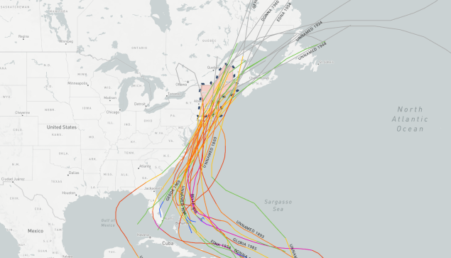
Map showing the track of all of the hurricanes that crossed New England since 1851. Image provided by NOAA.
Here in New England, we should always pay attention when a storm is nearing the Bahamas, as those are the ones that have the potential to impact us, and we are extremely overdue for a hurricane to make landfall. Using the HURDAT database which has data back to 1851, here are some stats that show exactly how overdue we are:
Since 1851, 39 storms of tropical storm strength of greater have made landfall in New England or Long Island, an average of one every 4.5 years. The longest we’ve ever gone without one is 11 years, between 1897 and 1908 and also between 1923 and 1934. In 2021, we had two tropical storms (Elsa and Henri) make landfall in the region, so it’s been 4 years, which means we are due for another.
Since 1851, 32 strong tropical storms (maximum sustained winds of 60 mph or more) have made landfall in New England or Long Island, an average of one every 5.4 years. The longest we’ve ever gone without one is 19 years, between 1897 and 1916. In 2021, we had two strong tropical storms (Elsa and Henri) make landfall in the region.
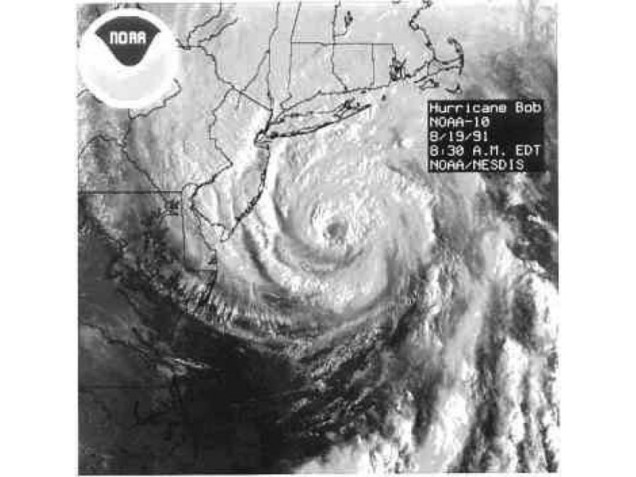
Since 1851, a hurricane has made landfall in New England or Long Island 18 times, an average of one every 9.7 years. The longest we’ve ever gone between hurricane landfalls is 38 years, between 1896 and 1934. It’s now been 34 years since Hurricane Bob, our 2nd longest drought on record.
Since 1851, 8 hurricanes of Category 2 intensity or stronger have made landfall in New England or Long Island, an average of one every 21.8 years. The longest we’ve gone between hits by storms of that intensity is 69 years, between 1869 and 1938. We’re at 34 years since Bob, the last one to do so.
Since 1851, New England/Long Island has had 3 Major Hurricanes (Category 3 or higher) make landfall – an unnamed storm in October of 1869 that grazed the eastern tip of Long Island before making landfall just west of Charlestown, RI; the infamous 1938 Long Island Express that made landfall near Brookhaven, NY and then again near New Haven, CT; and Hurricane Carol in 1954 which crossed East Hampton, NY and then made a 2nd landfall near Groton, CT. That’s an average of 1 every 58 years, and we’re now at 71 years since Carol, making this the longest stretch on record. There are also 3 documented storms from before 1851 – The Great Colonial Hurricane of 1635, the 1815 New England Hurricane, and the Norfolk and Long Island Hurricane of 1821. That’s it. That changes the numbers to 6 in 390 years, or one every 65 years, with a longest drought of 180 years.
Satellite photo of Hurricane Bob approaching New England. Bob was the last hurricane to make landfall in New England – 34 years ago. Image provided by NOAA.
We all saw what Sandy did back in 2012, and that was a minimal hurricane that eventually made landfall in southern New Jersey (technically as an extratropical storm), though there were other factors that led to the amount of damage it caused. When (not if) the next big storm comes up the coast, much of this region will not be prepared for the storm or its aftermath. A storm doesn’t need to make a direct hit on New England to have significant impacts. In addition to Sandy, the so-called “Perfect Storm” in 1991 was an offshore system that became a hurricane and battered the coastline with strong winds and significant coastal impacts for a few days around Halloween. In 1955, Hurricane Connie and Tropical Storm Diane both made landfall in North Carolina 5 days apart. Connie tracked into the eastern Great Lakes, but still produced some heavy rain in New England, especially western New England. A few days later, Diane passed just south of New England on its way out to sea, but produced widespread rainfall totals of 5-15 inches across most of southern New England, with 19.75″ in Westfield, Massachusetts. The combination of these back-to-back storms resulted in some of the worst flooding this region has ever seen.
Rainfall totals from Tropical Storm Diane in August, 1995. Image provided by NOAA.
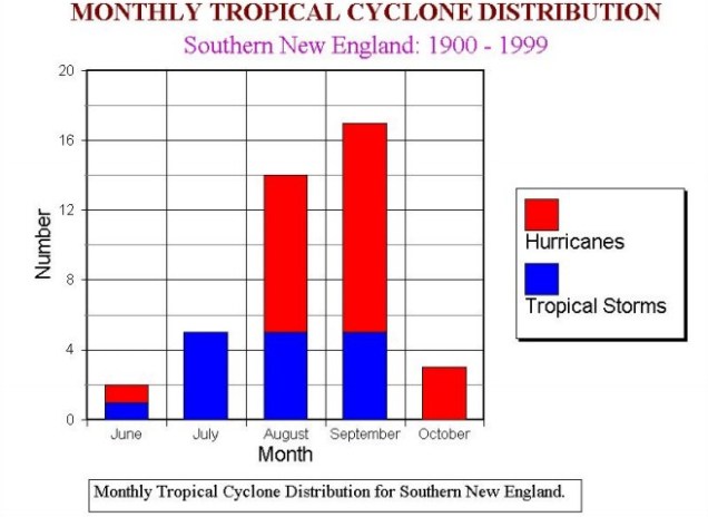
The Atlantic is quiet right now, but even if something were to form off the East Coast in the next few weeks and head this way, the waters off of New England are still much too cold to sustain a tropical system, so we’d see something more like a typical nor’easter. Only two tropical storms have ever made landfall in the Northeast before the end of June. The first was an unnamed minimal tropical storm that crossed extreme eastern Long Island and went into southeastern Connecticut on May 30, 1908. The other was Tropical Storm Agnes, which made landfall near New York City on June 22, 1972, then caused devastating flooding across parts of the Mid-Atlantic states. In terms of hurricanes, the earliest one to ever make landfall up this way was Hurricane Belle, which slammed into Long Island as a minimal hurricane with 75 mph winds on August 9, 1976. We did have Hurricane Arthur pass just offshore of Nantucket on July 4, 2014. While it did not make landfall, it made for a rather wet and cool holiday, especially across Cape Cod and southeastern Massachusetts. Statistically, the most likely time for a hurricane to hit New England is between the middle of August and late September. Of the 18 hurricanes that made landfall in New England or Long Island since 1851, 15 of them have done so between August 19 and September 27.
The most likely time for a tropical system to impact our area is August of September. Image provided by the National Weather Service office in Norton, MA.
As always, you should get your weather information from a trusted source (hopefully you trust us), especially when dealing with tropical systems. Much like with snowstorms in the winter, there will be plenty of hype and exaggeration on Twitter and Facebook, as well as people posting doom and gloom maps showing how a thunderstorm near the coast of Africa will develop into a Category 5 storm and head right for the East Coast in the next 2 weeks. We’re not among that group, we give you facts and our best forecasts, without any hype. If there’s reason to worry, we’ll let you know with plenty of advance warning. It’s always best to prepare ahead of the season. Chances are, you won’t have anything to worry about, but in case you do, it’s always good to be prepared.
We’ve got some better weather on the way for the first half of the upcoming week. Unfortunately, the second half of the week isn’t looking that great once again.
Tuesday is looking like the pick of the week. Image provided by Weathermodels.com
The upper-level low pressure area that kept the clouds and showers around through the weekend will finally pull away today and high pressure will start to build in, bringing us drier and milder weather. There will still be some clouds around, especially during the afternoon, and even though a couple of models still show the potential for a few stray popup showers, we expect it to remain dry, so any outdoor activities should be fine. Tuesday should be the best day we’ve had in a while, with sunshine and temperatures close to or a little above normal for the end of May. Wednesday will also be mild, but we’ll see clouds starting to move back in as another low pressure system heads our way. We may see some rain move in as early as Wednesday night, but Thursday looks like a day with some showers, though it probably won’t be a washout, and it likely won’t be as chilly as the past few days have been.
Another upper-level low pressure area brings in unsettled weather for the end of the week and the weekend. Images provided by Pivotal Weather.
After that, another upper-level low pressure system settles into the Northeast, and likely remains there into the weekend. Now this upper-low isn’t as strong as the one we just dealt with, so it shouldn’t be as chilly as the end of last week, but temperatures will likely be near to below normal for the latter half of the week and the weekend. In addition, there will be a daily chance for showers. None of the days will be a washout, and the activity will be scattered about each day, but we’re not expecting any completely dry days from Thursday into Sunday. There are some indications that drier and much warmer air could make an appearance for the start of the following week, but whether that happens and how long it may last if it does, are questions we can’t answer at this point.
There are some models showing the potential for much warmer weather next week. Image provided by WeatherBell.
Monday: Sunshine and some afternoon clouds. High 63-70, cooler across Cape Cod.
Monday night: Clear to partly cloudy. Low 45-52.
Tuesday: Partly to mostly sunny. High 71-78, cooler across Cape Cod.
Tuesday night: Partly cloudy. Low 49-56.
Wednesday: Becoming partly to mostly cloudy. High 70-77, cooler across the South Coast and Cape Cod.
Wednesday night: Mostly cloudy, chance for showers late at night, mostly near the South Coast. Low 49-56.
Thursday: Plenty of clouds with some showers likely. High 64-71.
Thursday night: Mostly cloudy with some additional showers. Low 52-59.
Friday: Partly sunny, chance for a few showers. High 68-75, cooler across Cape Cod.
Saturday: Intervals of clouds and sunshine with a chance for more showers. High 67-74.
Sunday: Partly sunny with more showers possible. High 66-73.
We’ve reached Memorial Day Weekend – “The Unofficial Start of Summer”, but it won’t feel like summer for most of the time.
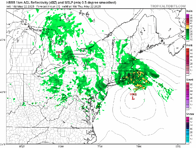
Low pressure will bring more rain and gusty winds in tonight. Loop provided by Tropical Tidbits.
A late-season nor’easter will slowly pull away from the region tonight and Friday, with rain and gusty winds continuing tonight, then winding down on Friday as the storm moves into the Gulf of Maine. So, the rest of the weekend is better, right? In the words of Lee Corso “Not so fast my friend”. We’ll still be under the influence of that storm, but we’ll also have an upper-level low pressure area moving into the Northeast. This means we’ll still have plenty of clouds, a few showers, and cool temperatures (but not as cool as today) into Saturday. Sunday should be a little better, with slightly milder conditions, less in the way of shower activity, but still a decent amount of clouds. As we head into the holiday on Monday, high pressure will build in, so it will be drier and milder, but with that upper-level low nearby, we can’t completely rule out the chance for another pop-up shower in the afternoon.
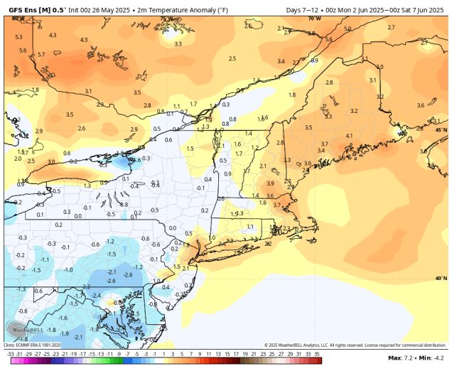
Memorial Day will be milder, but still cooler than normal around here. Image provided by weathermodels.com
Thursday night: Periods of rain, some of it heavy, windy. Low 39-46.
Friday: Rain tapers off to showers in the morning, clouds and a few glimpses of sunshine in the afternoon with a few more showers possible, still breezy in the morning, especially near the coast. High 50-57.
Friday night: Partly to mostly cloudy with more showers, especially before midnight. Low 43-50.
Saturday: More clouds than sun with some additional showers possible. High 53-60.
If you chose this week to be on vacation, then allow us to apologize in advance, because the weather won’t be that great for much of the upcoming week.
Temperatures will be well below normal for much of the upcoming week. Image provided by Weathermodels.com.
An upper-level low pressure system will continue to slowly pull away today, but it will still generate plenty of clouds, with a few showers possible. High pressure builds in for Monday night and Tuesday with drier and cooler conditions, but clouds will start to move back in during the afternoon on Tuesday ahead of our next low pressure system. That system will move into the Great Lakes on Wednesday, while a secondary storm develops across the Carolinas. That secondary storm will then slowly up the coast, with some showers developing Wednesday night. Thursday is looking like a miserable day with periods of rain and gusty northeast winds likely keep temperatures in the 50s or even upper 40s for much of the region. The rain will taper off to showers early Friday, but with an upper-level low pressure area hanging around into the weekend we’ll stay on the cool side with plenty of clouds and a few showers each day, including Memorial Day.
The models are all showing Thursday to be rather cool and rather wet. Images provided by Pivotal Weather.
Monday: Some morning sun, then partly to mostly cloudy and breezy with a few showers. High 59-66.
Monday night: Becoming partly cloudy. Low 40-47.
Tuesday: Morning sun, then increasing clouds. High 55-62.
Tuesday night: Mostly cloudy. Low 43-50.
Wednesday: Plenty of clouds, showers possible late in the day. High 51-58.
Wednesday night: Cloudy with showers likely. Low 41-48.
Thursday: Breezy and cool with rain likely. High 48-55.
Thursday night: Rain tapers off to showers. Low 40-47.
Friday: Lots of clouds with showers ending. High 52-59.
Saturday: More clouds than sun, chance for a few showers. High 56-63.
Sunday: Partly sunny, another shower or two possible, especially north and west of Boston. High 61-68.
Memorial Day: A mix of sun and clouds, chance for a few more showers. High 62-69.
Unsettled weather is expected at times during the weekend, but no washouts are expected.
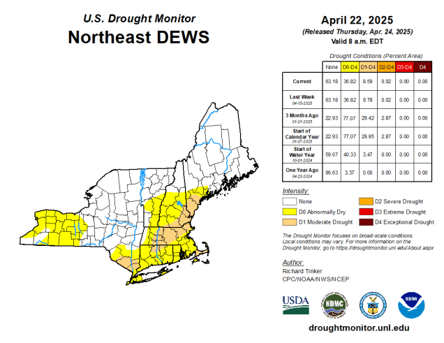
Recent rain has mitigated drought conditions for much of the region. Image provided by the National Drought Mitigation Center.
A weak low pressure area will start to pull away tonight with any lingering showers ending this evening, but areas of low clouds and fog will hang around overnight. Once the fog burns off Friday morning skies will become partly sunny, setting up a rather nice day with temperatures well into the 70s away from the South Coast, possibly topping 80 in some areas. A late-day shower or thunderstorm can’t be ruled out, mainly well north and west of Boston. A backdoor cold front may try and slide down the coast, bringing some cooler air into the New Hampshire Seacoast and the North Shore before it stalls out. Saturday will feature lots of clouds, with some showers and thunderstorms likely during the afternoon and evening as a cold front approaches the region. Some of these storms could produce gusty winds and heavy downpours, and possibly some hail. The front moves through overnight, with some clearing behind it. We’ll turn a little cooler on Sunday, but with an upper-level low pressure area crossing the region we’ll still have some clouds and possibly a few showers. Monday should feature partly sunny skies, but with the upper-level low nearby there is still a chance for a shower or two.
Most of the rain this weekend shouldn’t be that heavy. Image provided by WeatherBell.
Thursday night: Showers end in the evening, then mostly cloudy overnight with areas of dense fog developing. Low 54-61.
Friday: Becoming partly sunny, chance for a late-day shower or thunderstorm, mainly across the interior. High 74-81, cooler along the coast.
Friday night: Partly to mostly cloudy, fog may redevelop. Low 54-61.
Saturday: Mostly cloudy, showers and thunderstorms developing, mainly in the afternoon. High 69-76, cooler across Cape Cod and also from the North Shore to the New Hampshire Seacoast.
Saturday night: Showers and thunderstorms ending, some clearing late at night. Low 52-59.
Sunday: Partly sunny, chance for a few showers in the afternoon, breezy. High 66-73.
Sunday night: Partly cloudy. Low 47-54.
Monday: A mix of sun and clouds, just a slight chance for a shower, breezy. High 62-69.
The forecast for this week is both simple and not-so-simple.
Parts of the region have received quite a bit of rain so far this month and more could be coming. Image provided by Weathermodels.com
The simple part of the forecast is that we can basically split it in half, because changes will be slow to occur. The not-so-simple part is when those changes happen. We start the week off with high pressure in control both at the surface and aloft. This will result in sunshine and seasonably warm temperatures today. The high will slide off to the east tonight and Tuesday and high clouds will start to stream in, gradually thickening up on Tuesday. This is where the not-so-simple part begins. An upper-level low pressure system over the Southeast will gradually start to lift northeastward over the next day or two, but will weaken as it does so. The rain shield around this system may get as far north as New York City and southwestern Connecticut by Tuesday, but the high pressure system off to our east will prevent it from getting much farther north and east. Eventually it will start to erode the dry air and make its way into the region from southwest to northeast, but this may not occur until later Wednesday or Thursday. After that, a series of weak upper-level disturbances will move in, bringing us some occasional showers from Thursday into Friday and likely Saturday as well. None of the days will be a washout, and it won’t be raining the entire time, but it will be more humid as winds shift more toward the south and southwest. This will keep south-coastal areas cooler, as water temperatures off the South Coast are still in the middle to upper 50s, but inland, temperatures could top 70 once again. By later Saturday and Sunday, another upper-level low will move into the Northeast, bringing some additional showers and cooler conditions.
Sunday’s temperatures are highly dependent on whether it’ll be clearing or still raining. Images provided by Pivotal Weather.
Monday: Plenty of sunshine, breezy. High 68-75, cooler across the South Coast and Cape Cod.
Monday night: High clouds start to drift in towards evening, clouds become more widespread late at night. Low 49-56.
Tuesday: Filtered sunshine in the morning, then becoming mostly cloudy in the afternoon. High 67-74, cooler across east-facing shorelines.
Tuesday night: Partly to mostly cloudy. Low 46-53.
Wednesday: More clouds than sun. High 67-74, a little cooler at the coast.
Wednesday night: Mostly cloudy with showers possible. Low 51-58.
Thursday: Plenty of clouds with a chance for a few showers. High 66-73, cooler across east-facing shorelines.
Thursday night: Mostly cloudy, chance for a shower or two. Low 53-60.
Friday: Partly to mostly cloudy, chance for a few showers. High 72-79, a little cooler at the coast.
Saturday: Intervals of clouds and sun with more showers possible. High 72-79, a little cooler at the coast.
Sunday: Partly sunny, chance for a few showers. High 66-73, a little cooler at the coast.
The weather pattern will significantly improve for the second half of this weekend. Of course, that means that the first half of the weekend won’t be that great.
Friday’s temperatures will be 10-15 degrees below normal for much of the region. Image provided by weathermodels.com
An upper-level low pressure system will move towards the Northeast tonight, triggering a few showers across the region. At the same time, a surface low pressure area will start to move up the coast. Ahead of that low, easterly winds off the still cool-Atlantic, combined with the rain the storm system will generate, will result in a very cool day on Friday, with temperatures likely not budging much from what they drop to tonight. Temperatures will only be in the 50s, with areas north of the Mass Pike and also along the east coast likely staying in the upper 40s. If the low-pressure system tracks across southeastern Massachusetts, as some models show, then temperatures could briefly spike into the 60s across that region, but this is far from certain. As for the rain, it looks like the steadiest and heaviest rain holds off until afternoon, but occasional showers are likely during the day. Rain continues Friday night, ending from southwest to northeast Saturday morning and early afternoon as the storm system moves into the Gulf of Maine. Some showers may linger into the afternoon, especially across southern New Hampshire, but we should finally start to see some clearing by evening. High pressure then builds in with sunshine and milder weather for both Sunday and Monday.
Much of the region could pick up 1-2 inches of rain between now and Saturday evening. Image provided by WeatherBell.
Thursday night: Mostly cloudy with some showers likely. Low 45-52.
Friday: Cloudy with more showers, becoming a steadier rain during the afternoon. High 48-55, possibly milder across parts of Rhode Island and southeastern Massachusetts.
Friday night: Rain likely. Low 44-51, possibly milder across parts of Rhode Island and southeastern Massachusetts.
Saturday: Showers ending by early afternoon, some clearing may start to develop late in the day, especially across Rhode Island and southern Massachusetts, becoming breezy. High 58-65.
Saturday night: Becoming clear. Low 45-52.
Sunday: Plenty of sunshine. High 64-71.
Sunday night: A few clouds around. Low 40-47.
Monday: More sunshine. High 69-76, cooler along the South Coast and Cape Cod.
Sunshine may be a little hard to come by this week for an extended period, but rainfall won’t be, which will help with the ongoing drought. At least it’s not snow, right?
An Omega Block will control the nation’s weather to start the week. Image provided by The Weather Channel.
The weather pattern to start the week across the nation is dominated by a pattern known as an “omega block”. With upper-level troughs of low pressure in both the East and the West, and a ridge of high pressure in the middle, the pattern resembles the Greek letter Omega. With an upper-level low in the East and drifting eastward slowly, that means we’ll be on the cool side to start the week, with some rainfall likely. The heaviest rain will likely fall across western New England today, but occasional showers in our area will persist today. As that upper-level low moves eastward, so will the surface low, so that rain in western New England today will shift into our area later tonight and Tuesday. Wednesday shouldn’t be as wet, but with the upper-level low moving across the region, we’ll still have some showers around. By Thursday, we may dry out a bit, but with another upper-level disturbance moving in, some more showers are possible.
Much of the region could receive a decent amount of rain this week. Image provided by Weathermodels.com
As we get to the end of the week and into the weekend, the upper-level low hangs around, and a surface low pressure system will be moving up the coast, bringing more rain and cool temperatures into the region. For Sunday, many of the models try to have high pressure building in with drier and milder weather. However, we know that the models struggle in this type of pattern, and historically are too quick to improve conditions around here. So, even though the models are forecasting Sunday to be rather nice, we’re going to hedge our bets a little. We should have a better idea how the weekend will play out for our Weekend Outlook Thursday afternoon.
The models all show a dry day on Sunday, but we’re not 100% sure yet. Images provided by Pivotal Weather.
Monday: Cloudy with occasional showers, mainly north and west of Interstate 95, breezy, especially along the coast. High 51-58, a little warmer south of Route 44.
Monday night: Cloudy with more showers, possibly becoming a steadier rain after midnight. Low 46-53, temperatures may start to rise after midnight.
Tuesday: Periods of rain and showers. High 59-66, a little cooler from the North Shore to the New Hampshire Seacoast.
Tuesday night: Cloudy with more showers likely. Low 49-56.
Wednesday: More clouds than sunshine with a chance for a few more showers. High 63-70, cooler across the Outer Cape and Islands.
Wednesday night: Partly cloudy. Low 48-55.
Thursday: Partly to mostly cloudy, chance for a few showers. High 65-72, cooler across the Outer Cape and Islands.
Thursday night: Mostly cloudy with some showers possible. Low 42-49.
Friday: Plenty of clouds with additional showers, some steadier rain is likely at night. High 50-57.
Saturday: Mostly cloudy with more showers expected. High 55-62.
Sunday: Intervals of clouds and sunshine. High 66-73, cooler across the Outer Cape and Islands.
It’s a weekend, so that must mean it’s going to rain.
We’re still experiencing drought conditions, so we need the rain. Image provided by the National Drought Mitigation Center.
We’ve got a low pressure area heading toward the Great Lakes, sending a warm front our way. A few showers may accompany that front across southern New Hampshire this evening, otherwise we’ll remain dry, setting up a rather mild Friday. While there will be some sunshine, it could be dimmed by smoke and haze drifting up from the large wildfires in New Jersey. That warm front may stall out and/or drift southward a bit on Friday, bringing cooler air back to the New Hampshire Seacoast and the North Shore, but otherwise, most places away from the South Coast should reach 70 once again. Clouds thicken up Friday night ahead of the low pressure area, with some rain moving in by daybreak. Saturday shouldn’t be a complete washout, but it will be fairly damp. Rain is likely through the morning, then there may be a bit of a lull by early afternoon, before another batch of showers accompanies a cold front late in the day. Some clearing is expected Saturday night, but an upper-level low moving across the Northeast on Sunday will generate more clouds, possibly a shower or two, and bring in cooler temperatures. High pressure returns on Monday with drier and milder conditions.
Thursday night: Chance for an evening shower across southern New Hampshire, otherwise partly cloudy. Low 48-55.
Friday: Partly sunny with some haze or smoke around in the morning, clouds thicken up during the afternoon. High 72-79 inland, 64-71 along the coast, a little cooler across the Outer Cape and Islands. Temperatures may turn cooler for a while in the afternoon from Boston northward, especially along the coast.
Friday night: Mostly cloudy, rain developing towards daybreak. Low 48-55.
Saturday: Cloudy and breezy with showers likely, tapering off late in the day. High 61-68, cooler across the South Coast, Cape, and Islands.