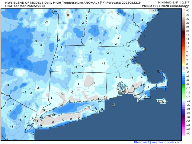
We’ve reached Memorial Day Weekend – “The Unofficial Start of Summer”, but it won’t feel like summer for most of the time.
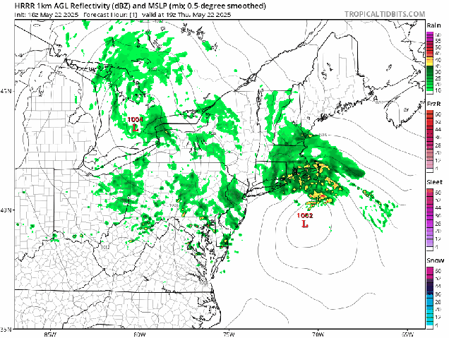
A late-season nor’easter will slowly pull away from the region tonight and Friday, with rain and gusty winds continuing tonight, then winding down on Friday as the storm moves into the Gulf of Maine. So, the rest of the weekend is better, right? In the words of Lee Corso “Not so fast my friend”. We’ll still be under the influence of that storm, but we’ll also have an upper-level low pressure area moving into the Northeast. This means we’ll still have plenty of clouds, a few showers, and cool temperatures (but not as cool as today) into Saturday. Sunday should be a little better, with slightly milder conditions, less in the way of shower activity, but still a decent amount of clouds. As we head into the holiday on Monday, high pressure will build in, so it will be drier and milder, but with that upper-level low nearby, we can’t completely rule out the chance for another pop-up shower in the afternoon.
Thursday night: Periods of rain, some of it heavy, windy. Low 39-46.
Friday: Rain tapers off to showers in the morning, clouds and a few glimpses of sunshine in the afternoon with a few more showers possible, still breezy in the morning, especially near the coast. High 50-57.
Friday night: Partly to mostly cloudy with more showers, especially before midnight. Low 43-50.
Saturday: More clouds than sun with some additional showers possible. High 53-60.
Saturday night: Becoming partly cloudy. Low 42-49.
Sunday: Partly sunny, chance for a few pop-up showers. High 57-64.
Sunday night: Partly cloudy. Low 43-50.
Monday: A mix of sun and clouds, just a slight chance for an afternoon shower. High 64-71.
