The forecast for this week is both simple and not-so-simple.

The simple part of the forecast is that we can basically split it in half, because changes will be slow to occur. The not-so-simple part is when those changes happen. We start the week off with high pressure in control both at the surface and aloft. This will result in sunshine and seasonably warm temperatures today. The high will slide off to the east tonight and Tuesday and high clouds will start to stream in, gradually thickening up on Tuesday. This is where the not-so-simple part begins. An upper-level low pressure system over the Southeast will gradually start to lift northeastward over the next day or two, but will weaken as it does so. The rain shield around this system may get as far north as New York City and southwestern Connecticut by Tuesday, but the high pressure system off to our east will prevent it from getting much farther north and east. Eventually it will start to erode the dry air and make its way into the region from southwest to northeast, but this may not occur until later Wednesday or Thursday. After that, a series of weak upper-level disturbances will move in, bringing us some occasional showers from Thursday into Friday and likely Saturday as well. None of the days will be a washout, and it won’t be raining the entire time, but it will be more humid as winds shift more toward the south and southwest. This will keep south-coastal areas cooler, as water temperatures off the South Coast are still in the middle to upper 50s, but inland, temperatures could top 70 once again. By later Saturday and Sunday, another upper-level low will move into the Northeast, bringing some additional showers and cooler conditions.
Monday: Plenty of sunshine, breezy. High 68-75, cooler across the South Coast and Cape Cod.
Monday night: High clouds start to drift in towards evening, clouds become more widespread late at night. Low 49-56.
Tuesday: Filtered sunshine in the morning, then becoming mostly cloudy in the afternoon. High 67-74, cooler across east-facing shorelines.
Tuesday night: Partly to mostly cloudy. Low 46-53.
Wednesday: More clouds than sun. High 67-74, a little cooler at the coast.
Wednesday night: Mostly cloudy with showers possible. Low 51-58.
Thursday: Plenty of clouds with a chance for a few showers. High 66-73, cooler across east-facing shorelines.
Thursday night: Mostly cloudy, chance for a shower or two. Low 53-60.
Friday: Partly to mostly cloudy, chance for a few showers. High 72-79, a little cooler at the coast.
Saturday: Intervals of clouds and sun with more showers possible. High 72-79, a little cooler at the coast.
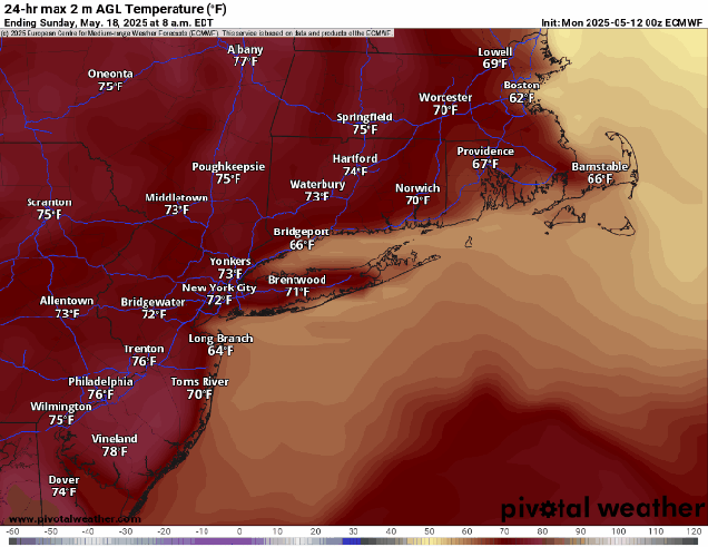
Sunday: Partly sunny, chance for a few showers. High 66-73, a little cooler at the coast.
