Another dreary weekend is on the way for the region, and there may even be some snow for parts of the region.
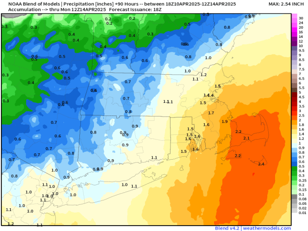
Low pressure will head toward the Mid-Atlantic states tonight, sending some showers our way. Across the interior, well north and west of Boston, temperatures will be marginally cold enough for the rain to change to snow, especially in the hills of Worcester County and the Monadnocks, but also some of the lower elevations outside of I-495. We’re not expecting any accumulation, though it wouldn’t be a shock if there was a coating on some grassy surfaces. The showers should taper off towards daybreak. and Friday will just be a cloudy day with a few stray showers possible. The low over the Mid-Atlantic states starts moving our way Friday night, with some steadier and heavier rain moving in, and continuing for much of Saturday. Again, we’ll have some marginally cold air in place Friday night, so we could see more snow mixing in, with a coating possible on grassy surfaces outside of 495, and possibly a little more than that in the hills of Worcester County and the Monadnocks once again. Saturday will be a rather chilly day with northeast winds keeping temperatures in the upper 30s and lower 40s for much of the region. Combine that with the rain, and it won’t be a great day to be outside. The rain tapers off Saturday night, but as that system starts moving toward the northeast and passes offshore, it could possibly bring in some more rain on Sunday, especially for eastern Massachusetts and Rhode Island. That system pulls away Sunday night and high pressure briefly builds in for Monday with some sunshine and milder conditions.

Thursday night: Cloudy with some showers developing, possibly mixed with snow across the interior. Low 32-39.
Friday: Cloudy and becoming breezy with a few showers possibly, mainly in the morning. High 43-50, coolest along the coast.
Friday night: Cloudy and breezy with rain developing, mixed with snow across the interior. Low 31-38.
Saturday: Breezy with periods of rain. High 37-44.
Saturday night: Rain tapers off the showers. Low 33-40.
Sunday: Cloudy and breezy with more showers possible, favoring eastern Massachusetts and Rhode Island. High 44-51, coolest across southeastern Massachusetts and Cape Cod.
Sunday night: Any showers end in the evening, becoming partly cloudy overnight. Low 34-41.
Monday: Partly sunny. High 56-63, cooler across Cape Cod.
