The weather looks fantastic for the Red Sox home opener at Fenway tomorrow, but the rest of the weekend doesn’t look that great.

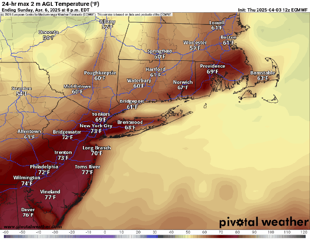
A cold front will cross the region this evening, possibly accompanied by a few showers tonight. The front settles south of New England on Friday, with some clearing taking place from north to south. Temperatures will remain mild, which is good news if you’re heading to Opening Day at Fenway. For first pitch at 2:10pm, skies will be partly sunny, winds out of the northwest at 10-15 mph (blowing from left field to right field), and the temperature will likely be in the lower 60s. Clouds will start to stream back in late Friday night as that frontal system starts lifting northward once again. Saturday is looking like a rather cool day with northeast to east winds off the ocean, and rain developing toward midday. Occasional periods of rain and showers are likely into the nighttime hours before tapering off. The front will lift through as a warm front on Sunday, but how far north it gets is still a question mark. Areas south of Boston should have a very mild afternoon, but how warm it gets north of Boston, especially into southern New Hampshire, is uncertain. If the warm front does get that far north, temperatures could get well into the 60s. If not, it could stay in the 50s or even upper 40s all afternoon. We’ll have some spotty showers at times, but the day shouldn’t be a washout. Another low pressure area moves through later in the day and at night with more rain likely. That system drags a cold front through at night, with cooler air moving in behind the system on Monday. Showers should gradually end during the day as the system moves offshore.
Thursday night: Mostly cloudy with a few showers possible, mainly south of the Mass Pike. Low 46-53.
Friday: Any lingering showers near the South Coast end early, followed by gradual clearing from north to south. High 58-65.
Friday night: Partly cloudy through the evening, clouds increase and thicken up after midnight. Low 35-42.
Saturday: Mostly cloudy and cooler with rain developing. High 41-48, temperatures may drop a little in the afternoon.
Saturday night: Rain tapers off to showers. Low 35-42, temperatures may start to rise after midnight.
Sunday: Plenty of clouds with a few showers possible. High 55-62, possibly warmer south of Boston.
Sunday night: Cloudy with more rain and showers. Low 36-43.
Monday: Mostly cloudy, showers ending. High 44-51.
