“March comes in like a lion and goes out like a lamb”
March isn’t going to come in like a lion this year, but a cheetah might be more accurate, since we’ve got a fast-moving storm system coming in for the start of the month.
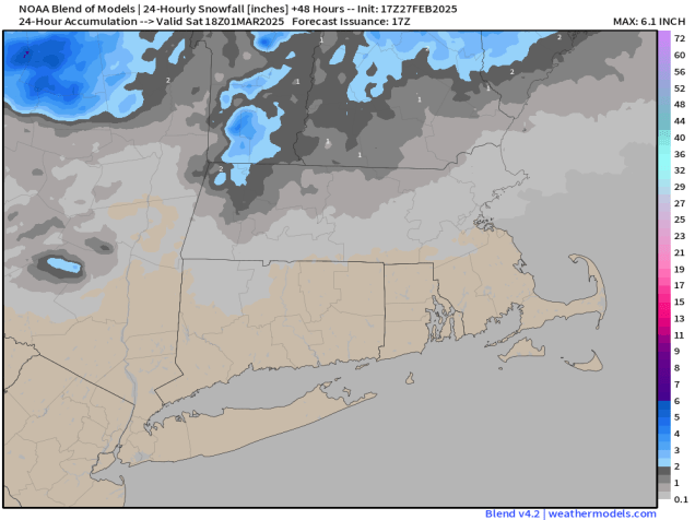
High pressure will build in for tonight and much of Friday with drier weather. With temperatures expected to drop below freezing tonight, there could be some icy spots developing on any untreated surfaces, especially ones that don’t see much sunlight during the day. Clouds stream back in late Friday ahead of a fast-moving storm system. We’ll see some light snow developing Friday night, but as milder air moves in, it should change to rain in most places as we get into Saturday morning before it winds down. Accumulations will be minor, if it accumulates at all, with an inch or less for most of us, maybe up to 2 inches in parts of central New Hampshire. Saturday could be another day, with a few breaks of sun developing, but a cold front will move through in the afternoon with some additional rain showers. We’ll clear out behind that front Saturday night, then high pressure builds in with sunshine and much colder weather for Sunday and Monday.

Thursday night: Mostly cloudy with any lingering showers ending in evening, skies start to clear out after midnight. Low 29-36.
Friday: Partly to mostly sunny, clouds start to filter in late in the day, breezy. High 39-46.
Friday night: Mostly cloudy, light snow developing north of the Mass Pike before midnight, rain showers south of the Pike. Snow changes to rain from south to north before daybreak. Low 25-32 during the evening, temperatures rise after midnight.
Saturday: Showers taper off in the morning, some sunny breaks develop, then another round of showers is expected in the afternoon, breezy. High 47-54.
Saturday night: Gradual clearing. Low 13-20.
Sunday: Plenty of sunshine, breezy, and colder. High 24-31.
Sunday night: Clear skies. Low 6-13.
Monday: More sunshine. High 25-32.
