As one storm ends, we look ahead to another one on the way for the weekend.
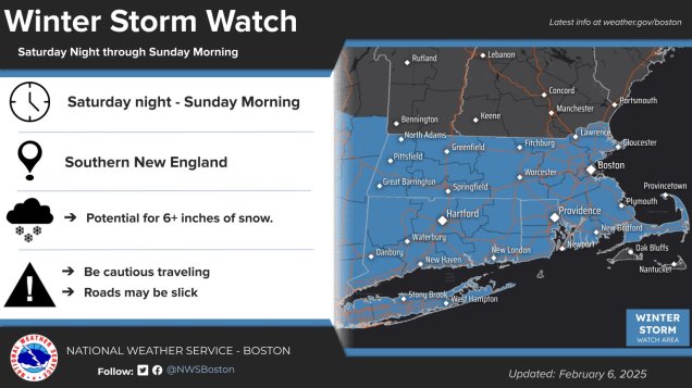
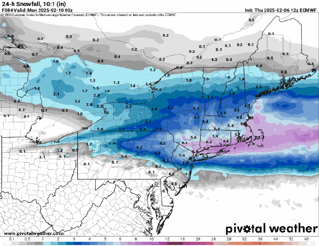
Low pressure pulls away from the region tonight and high pressure builds in, with clearing skies along with breezy and chilly conditions. The high will remain in control into Saturday, with diminishing winds Friday night, resulting in a rather chilly night. Clouds start to move back in later Saturday as another low pressure system heads our way. Unlike today’s storm, this one will be a little colder, and have a little more moisture to work with, so we’re looking at mostly snow for a good chunk of the region, possibly a little rain across the South Coast and Cape Cod. The snow will likely start around midnight Saturday night, give or take an hour or two, and continue into Sunday afternoon before winding down. This will not be a blockbuster snowstorm, but light to moderate amounts are likely. We’ll have another post tomorrow with a more detailed look at the storm, but our preliminary thoughts on accumulations are 4-7″ for most of the area. We’ll clear out Sunday night behind the storm, then high pressure builds back in for Monday. Our active weather pattern will continue into next week with more storm systems heading our way. More details on that in our Weekly Outlook early Monday.
Thursday night: Mostly cloudy, some clearing late at night. Low 25-32, temperatures may rise a little overnight.
Friday: A mix of sun and clouds, breezy. High 33-40.
Friday night: Clear to partly cloudy. Low 14-21.
Saturday: Some morning sun, then increasing and thickening clouds. High 28-35.
Saturday night: Cloudy with snow developing around midnight. Low 19-26.
Sunday: Snow ending by early afternoon, some late-day clearing. High 28-35.
Sunday night: Becoming clear. Low 7-14.
Monday: Mostly sunny. High 26-33.
