We’re in an active weather pattern with a storm that will produce a messy Thursday, and another one expected over the weekend.

We’ve got high pressure in control today with sunshine and chilly temperatures, but a low pressure system over the Tennessee Valley will send clouds in tonight as it heads our way. We’ll see a secondary area of low pressure develop off the North Carolina coast and head northeastward, passing very close to or across the South Coast of New England on Thursday. With the cold air in place, precipitation will start as all snow near or just after the morning commute on Thursday. However, warmer air will begin to move in aloft at first, and eventually at the surface, which will result in quite a mess during the afternoon. South of the Mass Pike, we’re looking at a brief change to sleet before it goes over the plain rain during the afternoon. North of the Mass Pike is where we will have some issues. A change to sleet and freezing rain is likely, resulting in slippery travel on untreated roads. North of Manchester, NH, precipitation may stay all snow. Everything should wind down during the evening, but that means the evening commute, especially from I-495 and points north and west, could be very hazardous.
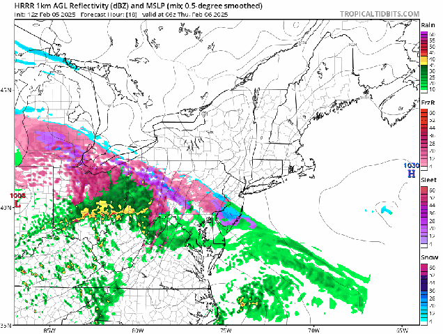
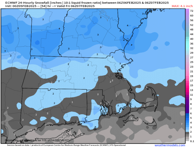
How much snow are we expecting? To be honest, not a lot. South of the Mass Pike, we’re looking at 1-2 inches. For MetroWest, the North shore, the Merrimack Valley, and over into the hills of Worcester County, 1-3 inches. For Southern and Central New Hampshire, 2-4 inches. Again though, it’s the freezing rain late in the day that will have as big or a bigger impact by late afternoon.
Once we get past that, we’ve got another storm on the horizon for the weekend. This one looks to be mostly Saturday night and Sunday morning, and could be fairly similar to tomorrow’s storm. However, it will likely be a few degrees cooler, and contain more moisture, so we could be looking at a moderate snowstorm around here. We’ll get into more details on this storm in our Weekend Outlook tomorrow afternoon.

The active pattern will continue into next week, with another storm possible towards mid-week, but we’ll worry about that one later, as it is far too early to get into any specifics.
