As we head into the final week before Christmas, Hanukkah, Kwanzaa, or whatever else you celebrate, we’ve got some active weather ahead. We also will officially enter astronomical winter this week, with the Winter Solstice at 4:20am on Saturday (Meteorological Winter started on December 1).

A weak low pressure system will pass south of the region today, but with plenty of dry air in place, most of the precipitation associated with that system will dry up before it gets here, with only a few flurries or freezing drizzle possible this morning. However, another system quickly follows that one. As it heads across southern Canada, it will drag a warm front across the region this evening, with some rain expected ahead of the front tonight into Tuesday morning. Temperatures will rise behind the warm front tonight, setting up a mild day on Tuesday, though a cold front will move through in the afternoon. We’ll clear out behind that front later Tuesday, but clouds quickly return on Wednesday as yet another system heads our way. This one will bring in some more rain Wednesday night into early Thursday, however, it may be cold enough for some snow across parts of southern New Hampshire and the Merrimack Valley at the start. Everything winds down Thursday morning as the system pulls away, with clearing Thursday afternoon.
Another weak system moves through on Friday with a few snow showers possible. For the weekend, we’re watching high pressure build in across southern Canada, and low pressure develop off the Mid-Atlantic states. Right now, it looks like the high will be the dominant force around here, with dry and very chilly weather, but that’s far from a lock at this point, so we’ll keep a close watch on it, in case things start to change.

Monday: Morning clouds with a flurry or some freezing drizzle possible, some afternoon sunny breaks develop. High 37-44.
Monday night: Partly to mostly cloudy with some light rain developing, becoming breezy after midnight. Low 34-41 during the evening, temperatures rise overnight.
Tuesday: Rain ends early, then a mix of sun and clouds with diminishing winds for the afternoon. High 50-57.
Tuesday night: Clear to partly cloudy. Low 30-37.
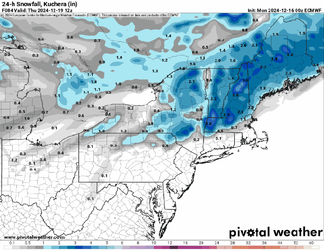
Wednesday: Becoming mostly cloudy, rain develops at night, possibly starting as snow north and west of I-495. High 42-49.
Thursday: Rain or snow ends early, skies clear out in the afternoon, breezy. High 39-46.
Friday: More clouds than sun with a few snow showers possible. High 29-36, a little warmer across southeastern Massachusetts and Cape Cod.
Saturday: A mix of sun and clouds, chance for some snow showers, mainly across Cape Cod. High 27-34, a little warmer across southeastern Massachusetts and Cape Cod.
Sunday: Partly to mostly sunny, quite chilly. High 17-24, a little milder across southeastern Massachusetts and Cape Cod.
