The first half of the week is looking quite active, with all sorts of hazardous weather for the region.

The week starts off with high pressure over Quebec keeping us dry, but that won’t last long. Low pressure heading into the Great Lakes sends some clouds our way, then a secondary low pressure system will develop, passing across southern New England tonight and early Tuesday. The result will be a period of rain for much of the region, starting late this afternoon, and ending shortly after midnight, but that’s not the entire story. Across southern New Hampshire, temperatures may be cold enough for the precipitation to start as snow, with some accumulation expected, mainly from Manchester northward. By evening, warmer air will move in aloft, but cold air may get trapped at the surface, so we could be looking some freezing rain, again, mostly from Manchester northward. Precipitation tapers off to drizzle or freezing drizzle after midnight as the system pulls away. Tuesday looks to be a cloudy day with some patchy drizzle at times, and temperatures holding steady or only very slowly rising as we head through much of the day.

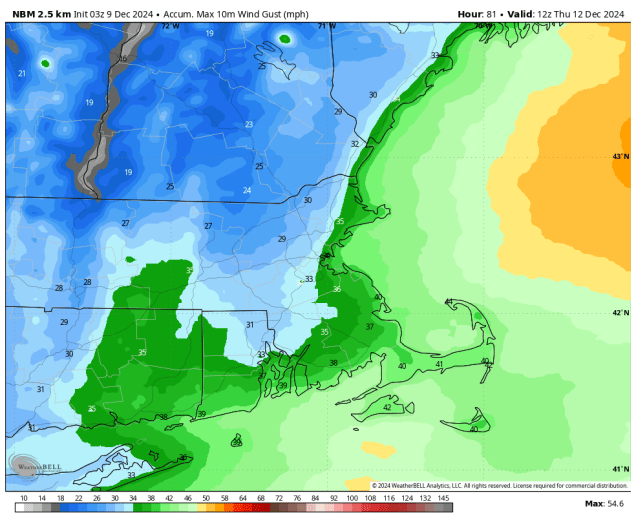
Another low pressure will start to make its way toward us Tuesday night into Wednesday, and this one will have some significant impacts on the region. We’ll see rain developing Tuesday night, continuing into Wednesday and it could be heavy at times. Many models are showing the potential for 1-2 inches of rain (or more), which would help put a dent in the ongoing drought. Accompanying the rain will be gusty south to southwest winds. Many models are showing the potential for wind gusts in excess of 40 mph across the region, with several showing even stronger winds, especially across eastern and southeastern Massachusetts. We’re skeptical that winds could be as strong as some of the models are showing, but it will be a windy day for sure. Those winds will also bring unseasonably warm air in, with temperatures likely getting well into the 50s across much of the region, with some places possibly topping 60. As the system passes by Wednesday night, it will drag a strong cold front through near or just after midnight. This will bring a quick end to the rainfall, but will also usher much colder air into the region. Many places could still be in the 50s or warmer at midnight, but will drop into the 30s by daybreak, and then hold steady or drop some more during the daytime hours despite clearing skies.
High pressure builds in for later Thursday into Saturday with mainly dry and cool conditions. Sunday is a bit of a question mark at this point. Some models show the potential for another system to move in with unsettled weather, some delay that storm until Monday, and some have it stay well to our south. At this point, it’s just too early to determine which, if any, solution is correct, so we’ll worry more about that in our Weekend Outlook on Thursday.

Monday: Some morning sun, then becoming mostly cloudy with rain developing late in the day, except snow developing in southern New Hampshire. High 40-47.
Monday night: Cloudy, snow changing to freezing rain and potentially plain rain across southern New Hampshire, showers across the rest of the region, with everything winding down shortly after midnight, but a little drizzle or freezing drizzle may linger late at night. Low 28-35 north and west of I-95, 36-43 south and east of I-95.
Tuesday: Plenty of clouds with some spotty drizzle, maybe some freezing drizzle across southern New Hampshire. High 33-40 north of the Mass Pike 41-48 south of the Pike, a little warmer across Cape Cod and the South Coast.
Tuesday night: Cloudy with showers developing, possibly starting as a little freezing rain across central New Hampshire. Low 32-39 during the evening north and west of I-95, 40-47 south and east of I-95, temperatures slowly rise overnight.
Wednesday: Cloudy with periods of rain, some of it could be heavy, becoming windy. Rain ends shortly after midnight. High 56-63.
Thursday: Becoming partly sunny, breezy, especially in the morning. High 36-43 early, temperatures hold steady or drop during the day.
Friday: Sunshine and some afternoon clouds. High 30-37.
Saturday: Mostly sunny in the morning, clouds start to move in during the afternoon. High 34-41.
Sunday: Partly to mostly cloudy with a chance of rain, especially late in the day. High 38-45.
