We’re going to end 2024 on a stormy note, but 2025 begins with colder weather.
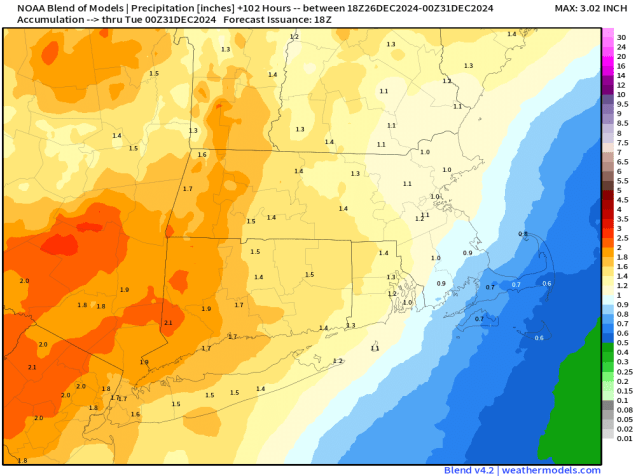
We’re starting the week off on a warm but wet note as a cold front makes its way across the region. Rain should end before midday, with gusty southerly winds keeping us mild ahead of the front. Once the front moves through, we’ll quickly clear out, but temperatures won’t drop that quickly. High pressure builds in for Tuesday with some sunshine and temperatures remaining fairly mild for late-December, but that won’t last long. Another low pressure system quickly follows, with another round of rain likely Tuesday night into Wednesday, so if you’ve got outdoor plans for New Year’s Eve make sure you bring an umbrella. This will help put another dent into the ongoing drought, but it will take a lot more rain to end that. Once that system moves out, high pressure builds in for Thursday through the weekend with breezy and colder weather, though a few flurries are possible at times.

Normally, we don’t forecast more than a week out, but we felt that it was worth mentioning what is going to happen during the following week. You’ll see in our forecast that temperatures gradually get colder as we go through the end of this week and the weekend, but all indications are that starting next week, a much colder airmass is going to settle in, and it may remain in place for a good chunk of January. Temperatures will be below to perhaps well below normal, and there may be some days, especially toward mid-month, where high temperatures struggle to reach 20, and low temperatures could drop below zero in parts of the region. There are also some indications that next week could be stormy, with the potential for one or two storms impacting the region, but this is far less certain. It’s way too early for any details on any potential storm systems, but the cold air seems far more likely, so we figured a heads up was warranted at this point.

Monday: Rain ending in the morning, skies start to clear out in the afternoon, breezy, especially in the morning. High 50-57.
Monday night: Mostly clear. Low 32-39.
Tuesday: Morning sun gives way to increasing afternoon clouds. High 44-51.
Tuesday night: Becoming cloudy with rain likely, possibly heavy at times. Low 34-41 during the evening, temperatures start rising after midnight.
Wednesday: Cloudy and breezy with rain tapering off to showers ending in the afternoon. High 43-50.
Thursday: A mix of sun and clouds, windy, and colder. High 34-41.
Friday: Partly to mostly sunny, breezy. High 30-37.
Saturday: Partly sunny, breezy. High 28-35.
Sunday: A mix of sun and clouds, breezy. High 25-32.