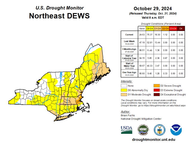
There’s not much rain in the forecast, and that’s not good for the worsening drought.
Unseasonably warm weather continues across the region into Friday ahead of a strong cold front. We’ll see clouds start to move in tonight as the cold front gets closer, but it doesn’t have a lot of moisture to work with, so we’re only expecting a few widely scattered showers when the front moves through late Friday morning. We’ll quickly clear out behind the front in the afternoon, but the cooler air lags a bit behind the front, so we’ll have another warm day, with temperatures likely topping 70 in many areas once again. High pressure then builds in for the weekend with much cooler weather, with temperatures a little below normal for early November. Clouds will start to move back in Sunday night and Monday as another warm front heads our way. We’ll likely stay on the cool side during the day, with any showers likely holding off until evening or more likely overnight, but again, we’re not expecting drought-busting rain, just some widely scattered showers.
Don’t forget – Daylight Saving Time ends at 2am Sunday, so you’ll get an extra hour of sleep when we turn the clocks back one hour.

Thursday night: Becoming partly to mostly cloudy, slight chance for a few showers toward daybreak, winds start to pick up late at night. Low 57-64.
Friday: Cloudy and breezy with a few widely scattered showers in the morning, skies quickly clear out after midday. High 71-78, a little cooler across Cape Cod.
Friday night: Clear to partly cloudy with diminishing winds. Low 40-47.
Saturday: Mostly sunny, much cooler. High 51-58.
Saturday night: Clear skies. Low 30-37.
Sunday: Sunshine with some afternoon clouds. High 48-55.
Sunday night: Becoming mostly cloudy. Low 30-37.
Monday: Plenty of clouds, a few showers possible toward evening. High 47-54.
