Our stretch of dry and warm weather will continue for a few more days, but changes are coming later this week.
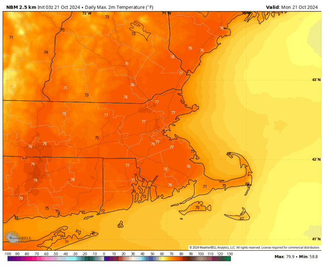
We start the week off with high pressure still in control, giving us dry and unseasonably warm conditions through Wednesday. High temperatures will likely top 70 in many areas each of the next 3 days, and a few places could even reach 80 this afternoon, though a backdoor cold front may bring some cooler weather into coastal areas on Tuesday. However, all good things must come to an end, and a stronger cold front will bring an end to the warm weather on Thursday. Breezy and cooler weather is likely with the frontal passage early in the day, but as has been the case for a while now, little rainfall will accompany it. After a couple of cool and dry days, another cold front will approach on Saturday. Once again, we’re not expecting drought-busting rainfall with this front, just a few widely scattered showers. Behind that front even cooler weather settles in for the end of the weekend.

Monday: Sunshine with just a few afternoon clouds. High 72-79, a little cooler across Cape Cod.
Monday night: Clear to partly cloudy. Low 49-56.
Tuesday: Plenty of sunshine. High 69-76, a littler cooler along the coast.
Tuesday night: Clear to partly cloudy. Low 49-56.
Wednesday: Mostly sunny. High 69-76, a little cooler across Cape Cod.
Thursday: Some morning clouds, then becoming mostly sunny, breezy, and much cooler. High 56-63.
Friday: Mostly sunny. High 52-59.
Saturday: Partly sunny, chance for a few widely-scattered showers. High 56-63.
Sunday: Partly to mostly sunny, breezy, and cool. High 50-57.
