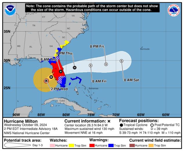
Hurricane Milton remains a Category 4 storm as it begins to close in on the Florida Gulf Coast.

After peaking as a Category 5 hurricane twice over the past few days, Hurricane Milton is starting to weaken, and will continue to do so right up until landfall along the Florida Gulf Coast tonight. As of 3pm EDT Milton still had maximum sustained winds near 130 mph, and was centered about 110 miles west of Ft. Myers, Florida, moving toward the northeast at 16 mph. A variety of watches and warnings are in effect for most of Florida as well as parts of the Bahamas and Southeast coastline.
At this point, the forecast for Milton is fairly straightforward. Upper-level conditions are becoming increasingly hostile, so Milton should continue to weaken, but will likely still be a Category 3 or Category 2 hurricane at landfall around or just after midnight tonight. It should turn a bit more toward the east-northeast this evening, with landfall likely south of Tampa Bay, probably somewhere in the vicinity of Sarasota. Once inland, it will move east-northeastward across Florida while continuing to weaken, likely emerging in the Atlantic Thursday morning as a Category 1 hurricane. It should then continue out into the open Atlantic. This track should keep the strongest winds south of Interstate 4, sparing the Tampa/Orlando/Daytona Beach areas from the worst of the conditions.
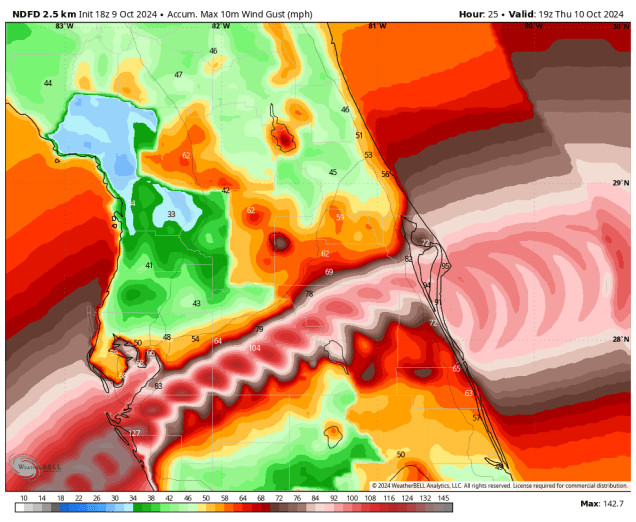
Milton has already begun to transition into an extratropical system, and by the time it moves into the Atlantic Thursday morning, that transition should be nearly complete. Unfortunately, this will result in Milton becoming and even larger storm, and the strong winds, albeit weaker than they are now, spread out over a much larger area. While the winds will result in widespread damage, especially near landfall, the strongest winds should stay south of Tampa, Orlando, and Daytona Beach. These areas may see gusts to hurricane strength, especially in Tampa, but wind will not be the biggest concern here.
Heavy rain has been falling across parts of Florida, especially central Florida for a few days now, and Milton will only worsen that. Much of the region has received 1-4 inches of rain already this week, and along and north of the track, additional rainfall totals of 10-15 inches or more are likely by Thursday morning, resulting in widespread significant flooding. This does include the metro areas of Tampa, Orlando, and Daytona.

The biggest concern is along the Florida Gulf Coast, where a large storm surge is expected near and south of where the center makes landfall. Milton has been piling up the water in the Gulf for a couple of days now, and even though it has begun weakening, the seas will not subside much, if at all, before landfall. A storm surge if 10-14 feet is expected from the mouth of Tampa Bay southward to the Charlotte Harbor area. With landfall expected near or just before high tide, it will exacerbate the storm surge a bit more. Much of the remainder of the Florida Gulf Coast can still expect a significant storm surge, especially southward, including the Naples and Fort Myers areas, but with the storm passing south of Tampa Bay, we were spared the worst-case scenario of a storm passing just to the north, sending a 15-foot storm surge right up the Bay and into downtown Tampa. Storm surge will also be a concern, but to a lesser degree along the Atlantic coast, mainly across central and northeastern Florida from Melbourne to Jacksonville, where a 3-5 foot storm surge is still expected.

If that wasn’t enough, Milton will also produce numerous tornadoes across parts of central and southern Florida today and tonight. There have already been more than half a dozen reports of tornadoes across parts of the area, and a Tornado Watch remains in effect through this evening for much of central and southern Florida. It will almost certainly be extended through the night.

Hurricane Milton peaked as a Category 5 storm on Monday with a central pressure of 897mb. The lower the pressure the stronger the storm. This made it the 5th strongest storm on record in the Atlantic Basin, and one of just 7 storms to have a central pressure of 900mb or lower. The last storm to do so was Hurricane Wilma in October of 2005. Wilma’s pressure bottomed out at 882mb, which is the lowest sea-level pressure recorded in the Atlantic, and second lowest in the western hemisphere (Hurricane Patricia in the Eastern Pacific had a pressure of 872mb in 2015).
| Storm | Pressure | Year |
| Wilma | 882mb | 2005 |
| Gilbert | 888mb | 1988 |
| Labor Day | 892mb | 1935 |
| Rita | 895mb | 2005 |
| Milton | 897mb | 2024 |
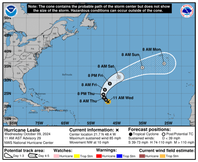
Milton isn’t the only active storm right now. We also have Hurricane Leslie, centered about 985 miles east-northeast of the Northern Leeward Islands, moving toward the northwest at 10 mph. Leslie weakened to a tropical storm on Tuesday, but has regained hurricane strength, with maximum sustained winds near 85 mph. Leslie may strengthen a little more tonight and Wednesday before a weakening trend commences. Leslie should turn more toward the north and northeast, remaining over open water while steadily weakening over the next few days, before becoming extratropical this weekend.
We’re also keeping an eye on an area of low pressure a few hundred miles west-southwest of Bermuda. It’s not tropical in origin, but it does have a small window over the next day or so where it could acquire some tropical characteristics, before upper-level conditions become unfavorable once again. Hurricane Season doesn’t officially end until November 30, so chances are, there will be more storms forming over the coming weeks.
