A good portion of the upcoming week will feature cool and dry weather. Meanwhile, all eyes are turning to Hurricane Milton in the Gulf of Mexico.

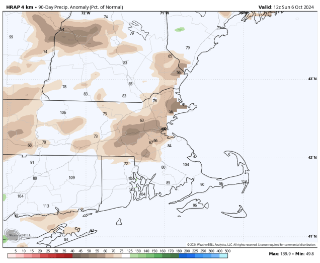
A cold front will cross the region today with some showers likely. While we need the rain, as we’re starting to slip into a drought, this will not be nearly enough rain to alleviate it. The front moves offshore late today, then we’ll clear out and turn cooler for Tuesday. With clear skies and light winds Tuesday night, some patchy frost is possible in the normally colder locations, especially well north and west of Boston. Another front moves through on Wednesday with little fanfare, but it will bring even cooler weather in for Thursday, when many locations likely won’t reach 60 for a high temperature. High pressure then slides offshore, allowing temperatures to moderate a little on Friday, and even more on Saturday, when many places may top 70 again. Another system may bring in some cooler and unsettled conditions for late Sunday and Columbus Day.
Meanwhile, the tropics remain active with three hurricanes, but one of them is a significant threat to land. As of 5am, Hurricane Milton was centered about 750 miles west-southwest of Tampa, Florida, moving toward the east-southeast at 5 mph. Maximum sustained winds were near 100 mph. Hurricane Warnings are in effect for parts of the Yucatan Peninsula, and Hurricane Watches are in effect for much of western Florida. Milton is expected to continue to strengthen for the next day or so, likely reaching Category 4 intensity as it turns more toward the northeast. However, by later Tuesday, upper-level conditions will become more hostile, and Milton should start to weaken, and in fact, could weaken rather quickly. However, it will still likely make landfall along the Florida Gulf Coast late Wednesday or early Thursday, but exactly where landfall will happen is still a question mark, and a fairly significant one. The strongest winds and highest storm surge will be to the right of the center. Some models bring the storm in near or north of Tampa, others to the south. A track south of Tampa means offshore winds for Tampa Bay, and not only would the storm surge be a lot less, it could actually send much of the water out of the Bay. However, a track just to the north of Tampa sends all the surge into the Bay, which would be very bad for the Tampa area. No matter where it makes landfall, it will bring additional heavy rain to much of Florida, with strong winds well inland. Once it makes landfall, it should continue to steadily weaken, and become extratropical as it moves off the east coast of Florida and into the Atlantic.

Well out in the Atlantic, we have Hurricanes Kirk and Leslie. As of 5am, Kirk still had maximum sustained winds near 75 mph, and was centered about 765 miles west-northwest of the Azores, moving toward the northeast at 30 mph. Kirk is expected to become extratropical later today as it heads eastward, and will bring strong winds and heavy rain to parts of northwestern Europe later this week. Meanwhile, Hurricane Leslie is centered about 1065 miles west of the Cabo Verde Islands, heading northwestward at 13 mph. Maximum sustained winds were near 90 mph. Leslie is expected to continue northwestward over open water this week while slowly weakening.

Monday: Cloudy with showers likely, ending late in the day. High 60-67.
Monday night: Clearing. Low 43-50.
Tuesday: Sunshine and a few clouds. High 59-66.
Tuesday night: Clear to partly cloudy. Low 38-45.
Wednesday: Sunshine and some afternoon clouds. High 58-65.
Thursday: Mostly sunny, breezy, and cool. High 54-61.
Friday: Lots of sunshine. High 58-65.
Saturday: Partly to mostly sunny, breezy, and milder. High 66-73.
Sunday: A mix of sun and clouds, showers possible at night. High 61-68.
Columbus Day: Partly to mostly cloudy and breezy with a chance for showers. High 53-60.
