“Summer’s going fast, nights growing colder.”
That line from “Time Stand Still” by Rush, often describes late August or September around here, and it will for at least part of this week.
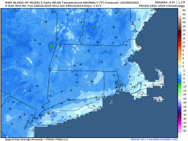
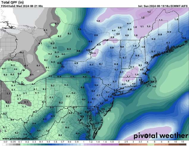
We’re starting the week off with a slow-moving cold front making its way across the region, resulting in aa fairly damp Monday with occasional showers and a few embedded thunderstorms. The front moves offshore early Tuesday, with showers coming to an end, and some clearing behind the front by late in the day as high pressure starts to build in. However, an upper-level low pressure system will then settle into the Northeast for Wednesday and Thursday. As a result, both days will start off with some sunshine, then clouds will develop, with a few showers possible each afternoon. Temperatures will be quite cool, with many places likely staying in the 60s for highs. We could even see a few of the normally cooler locations drop into the 40s at night. As the upper low moves out and high pressure slides offshore, we’ll start to warm up for the end of the week and the weekend, with temperatures getting back to near to above normal levels. Another system could move in by the end of the weekend with some unsettled weather, but the more likely scenario is that it holds off until the start of next week.
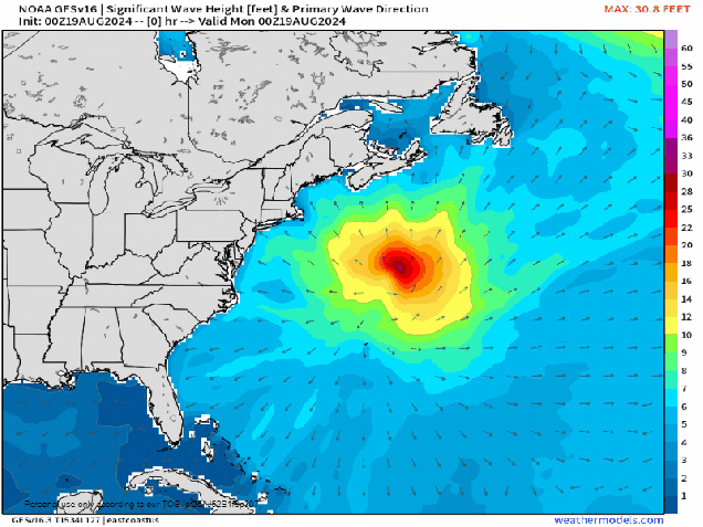
Hurricane Ernesto will continue to generate large swells at the beaches for a few more days, so use caution if you have plans near the coast. As of 11pm Sunday, Ernesto was centered about 435 south-southeast of Halifax, Nova Scotia, moving off toward the north-northeast at 20 mph. Maximum sustained winds were near 80 mph. Ernesto is expected to turn more toward the northeast and east-northeast today, passing south of Newfoundland tonight as it becomes extratropical.
Finally, we’d like to acknowledge that today marks the 33rd anniversary of Hurricane Bob making landfall along the South Coast. We’ve had some close calls in the years since then, but have not had a hurricane make landfall in New England or Long Island since Bob. This is the 2nd longest landfall drought on record for the region. Since 1851, 18 hurricanes have made landfall in this area, or one every 9.6 years, so we are very overdue. Of the 18 hurricanes that made landfall in New England or Long Island since 1851, 15 of them have done so between August 19 and September 27, so this is the time of year that we need to be especially vigilant, though the Atlantic looks to remain quiet for at least the next week or so.

Monday: Mostly cloudy with occasional showers, a rumble or two of thunder, and a few breaks of sunshine. High 74-81.
Monday night: Partly to mostly cloudy with a few more showers. Low 57-64.
Tuesday: Any lingering showers end early, some clearing develops late in the day. High 67-74.
Tuesday night: Becoming clear. Low 50-57.
Wednesday: A mix of sun and clouds, chance for a few showers. High 65-72.
Thursday: Sunshine and some afternoon clouds, chance for a shower or two. High 67-74.
Friday: Mostly sunny. High 73-80.
Saturday: Partly sunny. High 77-84.
Sunday: A mix of sun and clouds. High 78-85.
