Tropical Storm Ernesto developed just east of the Leeward Islands on Monday and crossed the Virgin Islands late Tuesday.

The disturbance we had been watching for several days finally got itself organized enough to be classified as Tropical Storm Ernesto late Monday afternoon. The storm passed very close to Guadeloupe as it crossed the Leeward Islands Tuesday morning, producing wind gusts as high as 65 mph on St. Barthelemy. The storm crossed the US Virgin Islands Tuesday evening, producing a gust to 79 mph on Buck Island in St. Thomas. As it pulled away, it produced sustained winds of 68 mph and a gust to 86 mph on Culebra, just off the northeastern coast of Puerto Rico. As of 5am EDT, Ernesto was centered about 85 miles north-northwest of San Juan, Puerto Rico, moving toward the northwest at 16 mph. Maximum sustained winds had increased to 70 mph.

A trough of low pressure moving off the East Coast will help turn Ernesto northward over the next day or two, passing northeast of Puerto Rico overnight and early Wednesday. Upper-level conditions will be favorable for development, and with very warm water in the western Atlantic, Ernesto could rapidly strength once it gets a little better organized. The current forecast calls for Ernest to become a hurricane later today, and it could become a major hurricane before the end of the week. As a ridge of high pressure tries to build back in, Ernesto may slow down a bit toward the end of the week as it starts to approach Bermuda. The current forecast calls for Ernesto to pass very close to Bermuda late Friday or Saturday as a Category 2 or 3 hurricane. However, it is important to note that forecast errors with tropical systems can be quite large, in terms of both track and intensity that far out. Still, anyone on Bermuda or with plans to head there late this week should pay very close attention to Ernesto’s progress.

Once past Bermuda’s latitude, another trough of low pressure will move off the East Coast, which should help to steer Ernesto off toward the northeast and eventually east. The question is, how close does Ernesto get to Nova Scotia and/or Newfoundland. This is still a week or so away, and Ernesto will almost certainly be extratropical by that point, but it is impossible to tell what, if any, impact Ernesto may have on Atlantic Canada, but again, residents of these areas should keep a close eye on the storm. Large swells generated by Ernesto will begin to impact much of the East Coast later this week and this week, creating rough seas offshore, and the risk for rip currents and possibly coastal flooding as well, as tides reach astronomical highs this weekend and early next week. Keep this in mind if you have beach plans this weekend anywhere in the Northeast or Mid-Atlantic states.
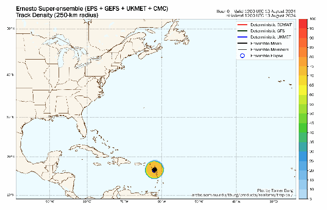
Ernesto generated a lot of hype before it even developed. Several forecast models showed the potential for the storm to develop into a potent hurricane and possibly threaten the East Coast. In turn, these maps got shared all across social media, spreading the hype. While the models can be helpful tools, their effectiveness, especially out 10-14 days as these forecasts were, is very limited. The model ensembles, which are essentially multiple versions of the same model run anywhere from 20-100 times with slight tweaks, showed the more likely scenario that actually played out, of a storm staying well off the East Coast. As you can see in the map above, none of the dozens of ensemble members show a threat to the East Coast at this point. Next time you see someone sharing a map that shows a storm threatening the East Coast two weeks in advance, keep this in mind. This is no different than in the winter when a model shows a paralyzing blizzard for the Northeast 10-14 days in advance, and it doesn’t materialize.
