The long weekend will feature typical summertime weather – warm temperatures, moderate to high humidity, and a daily chance for pop-up showers and thunderstorms.

After a couple of warm but dry days, we’ll see humidity levels increasing over the next few days thanks to southwest winds. A weak front will move in for the Fourth of July, but it won’t ruin any plans you may have. It will bring in some clouds, but only a few widely scattered showers and/or thunderstorms. So, keep an eye to the sky if you’ve got outdoor plans, but don’t go cancelling them, as most places will remain dry. Some patchy dense fog is likely Thursday night, especially near the South Coast, but it shouldn’t impact any fireworks displays. Friday looks like a typical summertime day with partly sunny skies, warm and humid conditions, and a few pop-up showers or thunderstorms. Another weak system moves in for Saturday, resulting in a very humid day, with a better chance for showers and thunderstorms, especially late in the day and at night. Sunday and Monday will be similar to Friday, with intervals of sun and clouds, fairly humid conditions (but not as humid as Saturday), and a few widely scattered showers and thunderstorms each afternoon.
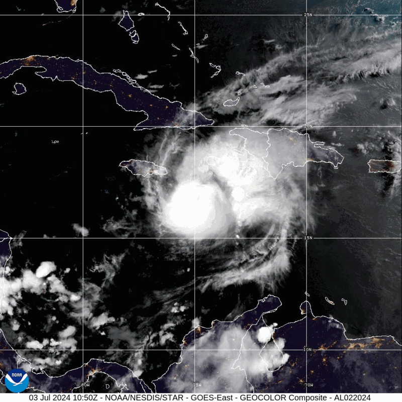
Meanwhile, in the tropics, Hurricane Beryl is barreling towards Jamaica this afternoon. As of 2pm, Beryl was centered about 45 miles south of Kingston, Jamaica, moving toward the west-northwest at 18 mph. Maximum sustained winds were near 140 mph, making Beryl a Category 4 hurricane. It is the strongest storm to impact Jamaica since Hurricane Dean in 2007. Damaging winds, torrential rain, and flooding are likely across Jamaica for the rest of the afternoon and evening, especially southern portions of the island, then Beryl will head toward the Cayman Islands tonight. Beyond that, it will continue across the Caribbean while gradually weakening before another likely landfall in the Yucatan Peninsula early Friday. It should weaken over the Yucatan, but it will move back into the Gulf of Mexico late Friday, then could strengthen once again. The models are split on whether it continues westward into Mainland Mexico or makes it a right turn and heads for southern Texas, but we’ll worry about that later this week.

Beryl has been shattering records over the past several days even before crossing the Windward Islands. It is the strongest storm ever in the Atlantic during the months of June and July. It is the earliest Category 5 hurricane ever in the Atlantic (by more than 2 weeks). It was the strongest storm to ever cross the Southern Windward Islands when it moved across Carriacou Island on Monday with top winds near 140 mph. Sea surface temperatures are well above normal across the Atlantic and Caribbean, which aided in Beryl getting so strong, but it also featured upper-level conditions that were nearly ideal for development and strengthening, which is not that common during June and July.
Wednesday night: Partly cloudy. Low 59-66.
Thursday: Partly sunny, more humid, slight chance for a shower. High 80-87, a little cooler near the coast.
Thursday night: Partly to mostly cloudy with a few showers possible and some patchy fog developing. Low 63-70.
Friday: Partly sunny, slight chance for a shower or thunderstorm. High 83-90, a little cooler across Cape Cod.
Friday night: Mostly cloudy, chance for a few showers. Low 64-71.
Saturday: More clouds than sun, very humid, chance for a few showers or thunderstorms. High 77-84.
Saturday night: Partly to mostly cloudy with a few showers or thunderstorms. Low 66-73.
Sunday: A mix of sun and clouds. High 85-92, a little cooler across Cape Cod.
Sunday night: Partly cloudy. Low 63-70.
Monday: Intervals of sun and clouds. High 84-91, a little cooler across Cape Cod.
