Tropical Depression Two Forms

Early season forecasts called for an active hurricane season in the Atlantic due to a multitude of factors, and so far, we’re off to a fast start.

Forecast track for Tropical Depression Two. Image provided by the National Hurricane Center.

Earlier in June, Tropical Storm Alberto brought heavy rain and some gusty winds to parts of Mexico and southern Texas. Given that this area has been in a drought, the rainfall was actually quite welcome, though probably not all at once. The moisture from Alberto also helped to get the Southwest Monsoon season off to an early start. Now as we approach the final days of June, we have a new Tropical Depression in the Atlantic, and it’s in a spot that we normally wouldn’t expect a storm to form this early in the season (more on that in a minute).

Tropical Storm Alberto brought very heavy rain to parts of northeastern Mexico earlier in June. Image provided by WeatherBell.

As of 5pm, the National Hurricane Center has initiated advisories on newly-formed Tropical Depression Two. It was centered about 1225 miles east-southeast of Barbados, moving toward the west at 21 mph. Maximum sustained winds were near 35 mph. The system should gradually strengthen, likely becoming Tropical Storm Beryl later tonight or Saturday, while heading off toward the west-northwest. It will likely become a threat to the Windward Islands by late Sunday or early Monday, but as of now, there are no watches or warnings in effect. Once it passes the islands, it should continue west-northwestward across the Caribbean, but obviously other factors can impact the exact track that it takes, as well as the intensity the storm reaches. Given that these forecasts have considerable uncertainty beyond 3-4 days, we won’t even begin to speculate on where it might head.
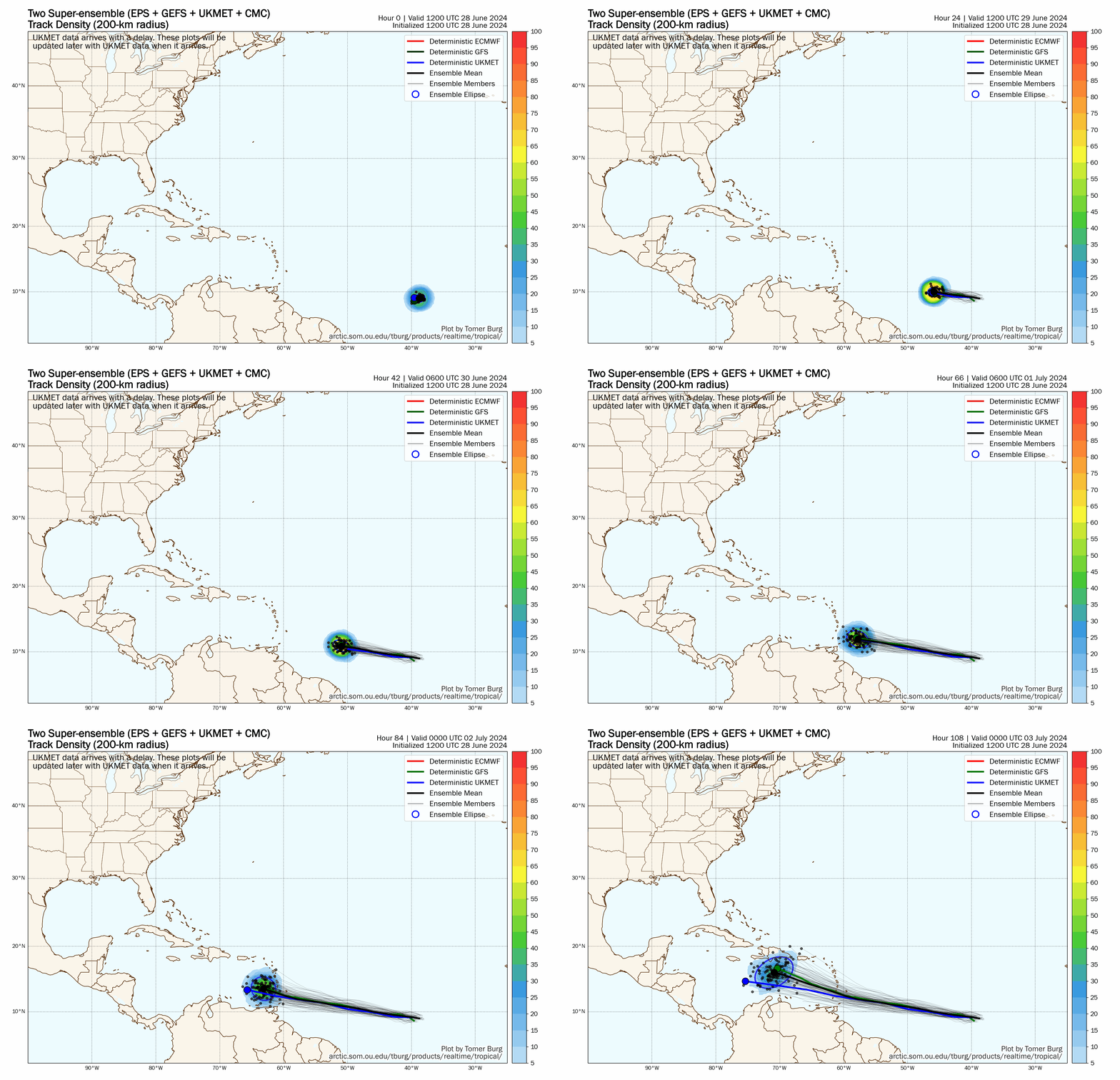
Forecast tracks for TD2 from the members of several model ensembles. Loop provided by Tomer Burg.

We’ve been keeping a close eye on this system for a few days now as the tropical wave responsible for the system has been crossing the Atlantic. The wave stayed rather far south, which is what helped it develop. To the north, there has been some Saharan Dust making its way across the Atlantic, and wind shear has been higher. Both of those factors inhibit the development of tropical systems, but by staying farther south and avoiding those, it has taken advantage of favorable conditions to gradually get organized this week.
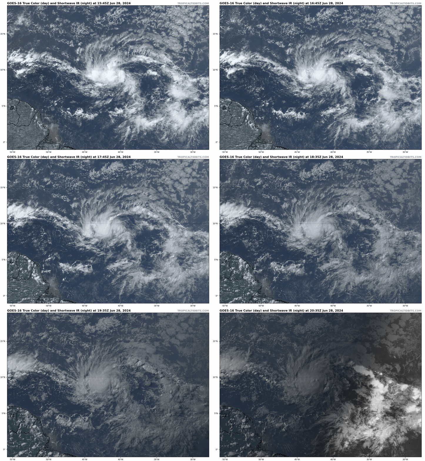
Satellite loop centered on Tropical Depression 2. Loop provided by Tropical Tidbits.

If this system can become a tropical storm before Sunday evening (and all indications are that it will), it will become only the 7th named storm to form east of the Caribbean during the month of June since 1851. The previous 6 storms were:

  • Unnamed Storm #2 in 1933
  • Tropical Storm Ana in 1979
  • Tropical Storm Bret in 2017
  • Tropical Storm Bonnie in 2022
  • Tropical Storm Bret in 2023
  • Tropical Storm Cindy in 2023

Of those six storms, only the 1933 storm reached hurricane strength during the month of June.

Tropical Depression Two isn’t the only storm we’re keeping an eye at this time. A tropical wave and associated area of low pressure are approaching the Yucatan Peninsula this evening. Once it moves into the Bay of Campeche on Saturday, there is a small window for the system to develop. Whether it does or not, it will bring another round of heavy rain into northeastern Mexico.

There are a couple of areas of interest across the tropics at this time Image provided by the National Hurricane Center.

There’s also another tropical wave way out in the Atlantic, several hundred miles south-southwest of the Cabo Verde Islands. It’s disorganized right now, and conditions aren’t favorable for development at this time, but as it makes its way across the Atlantic, it could move into a more favorable area by early next week.

Weekend Outlook: June 28 – July 1, 2024

More wet weather is on the way to close out June, but the weekend won’t be a washout.

Friday will be a refreshingly dry day with dewpoints only in the 40s across the region. Image provided by WeatherBell.

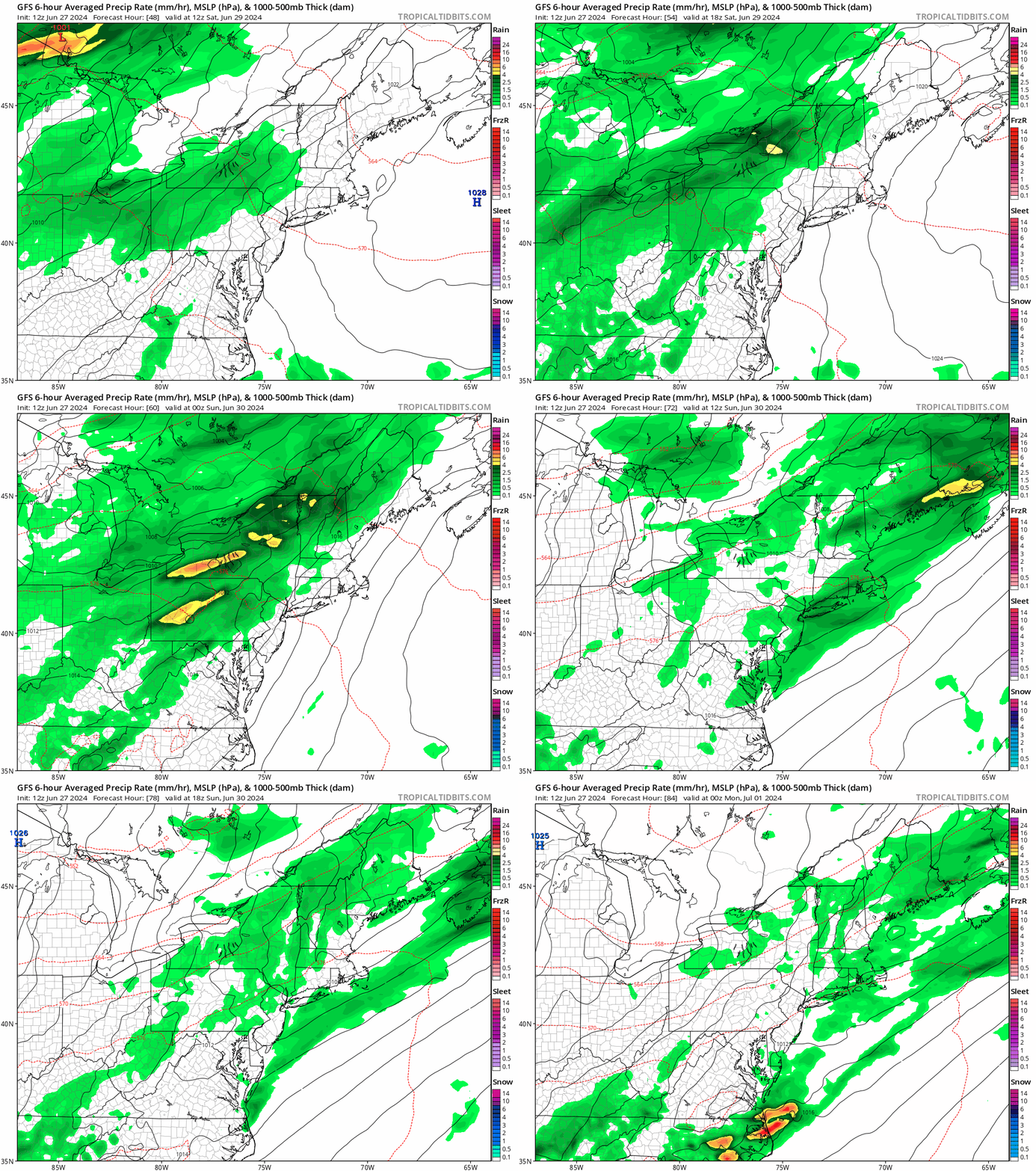
High pressure continues to build in for tonight and Friday with generally dry weather and seasonably mild temperatures. As the high slides offshore, warm and humid weather will move back in Friday night and Saturday along with clouds as a cold front approaches from the west. Most of Saturday should remain dry, albeit warm and humid, but another round of showers and thunderstorms will move in by evening, and continue overnight and into a good chunk of Sunday. The cold front moves through later Sunday, bringing an end to the shower activity, with drier weather pushing in behind it. High pressure builds back in for Monday with sunshine, cooler temperatures, and lower humidity once again.

Most of the rain this weekend will fall Saturday night and Sunday morning. Loop provided by Tropical Tidbits.

Thursday night: Clear and cool. Low 51-58.

Friday: Plenty of sunshine. High 71-78.

Friday night: Becoming partly cloudy. Low 54-61.

Saturday: Some morning sun, then skies become mostly cloudy and humid with some showers and thunderstorms possible by evening, breezy. High 73-80.

Saturday night: Cloudy and breezy with showers and thunderstorms likely. Low 63-70.

Sunday: Breezy with showers and thunderstorms ending, some clearing may take place late in the day. High 81-88.

Sunday night: Partly cloudy. Low 58-65.

Monday: Partly to mostly sunny. High 73-80.

Weekly Outlook: June 24-30, 2024

As we head into the last week of June, we’ll enjoy some warm weather with humidity levels rising and dropping at various points.

Dewpoints could drop into the lower 50s by Friday. Image provided by WeatherBell.

A cold front will move across the region during the day today, but moisture will be limited, so only a few stray showers will likely accompany the front. Drier air settles in behind it for tonight and Tuesday. High pressure builds in behind the front on Tuesday with plenty of sunshine and warm temperatures. Another cold front will begin to approach on Wednesday, with hot and humid weather returning. As the front moves in late in the day, another round of showers and thunderstorms is expected. The timing of the front will determine whether we’re looking at more severe weather or not, but the potential exists, as long as the front moves in during the afternoon. Showers and storms come to an end late Wednesday night or early Thursday, then high pressure builds back in with cooler and drier conditions for Thursday and Friday. As that high moves offshore, warmer and more humid weather returns on Saturday. Another frontal system may move in on Sunday, with another round of showers and thunderstorms possible.

Some models have showers and thunderstorms move in late Wednesday afternoon, others wait until evening. Images provided by Pivotal Weather.

Monday: A mix of sun and clouds, slight chance for an afternoon shower. High 79-86.

Monday night: Partly cloudy during the evening, clearing overnight. Low 58-65.

Tuesday: Sunny, not as humid. High 82-89.

Tuesday night: Partly cloudy. Low 64-71.

Wednesday: Early sun, then increasing clouds, showers and thunderstorms likely late in the day and at night, breezy, more humid. High 86-93, a little cooler near the South Coast.

Thursday: Becoming partly to mostly sunny, drier. High 77-84.

Friday: Plenty of sunshine. High 73-80.

Saturday: Partly sunny. High 77-84.

Sunday: Intervals of clouds and sun, chance for some showers and thunderstorms. High 81-88.

Weekend Outlook: June 21-24, 2024

The heat will relent for the weekend, but the humidity will take a bit longer.

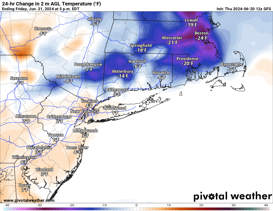
Friday afternoon temperatures will be 15-25 cooler than this afternoon across the region. Image provided by Pivotal Weather.

Today will be the last hot and humid day for a bit across the region, with some strong to severe thunderstorms bringing an end to the heat this afternoon and evening. The main threats with these storms are heavy downpours and gusty winds. Tonight will remain warm, but a backdoor cold front moves through on Friday, ushing much cooler air in, as winds shift into the northeast, and blow in over the still relatively cool Atlantic. Highs on Friday will only be in the 70s and 80s, warmest near the South Coast, where we’ll still get warm in the morning before the front moves through. Dewpoints will drop a bit, but will likely remain in the 60s, so it’ll be on the humid side still. Some showers are likely ahead of the front as well. The front stalls out near or just south of the region on Saturday, resulting in a rather comfortable day, but with a decent amount of clouds. On Sunday, that front will try to lift northward as a warm front once again, bringing the very warm and humid air back in. However, a disturbance moving in from the west will likely help to produce some showers and thunderstorms during the afternoon and evening. A cold front moves through on Monday, with warm, humid conditions ahead of it in the morning, along with more showers and thunderstorms, then cooler and drier air starts to move in by late in the day behind the front.

Dewpoints remain fairly high through the weekend, then finally start to drop late Monday. Loop provided by WeatherBell.

Thursday night: Showers and thunderstorms ending shortly after sunset, remaining partly to mostly cloudy overnight. Low 65-72.

Friday: Partly sunny with some showers likely. High 82-89 in the morning, turning cooler in the afternoon.

Friday night: Mostly cloudy, a few additional showers, mainly during the evening. Low 61-68.

Saturday: More clouds than sun, a few showers possible. High 77-84, a little cooler along the coast, especially the North Shore and NH Seacoast.

Saturday night: Mostly cloudy, chance for a shower. Low 60-67.

Sunday: Intervals of clouds and sun, breezy, showers and thunderstorms possible late in the day. High 83-90, cooler across the South Coast and Cape Cod.

Sunday night: Partly to mostly cloudy, showers taper off during the evening. Low 65-72.

Monday: A mix of sun and clouds, some showers around during the morning. High 79-86, a little cooler across Cape Cod.

Weekly Outlook: June 17-23, 2024

Ready or not, the first heat wave of the summer is on the way later this week.

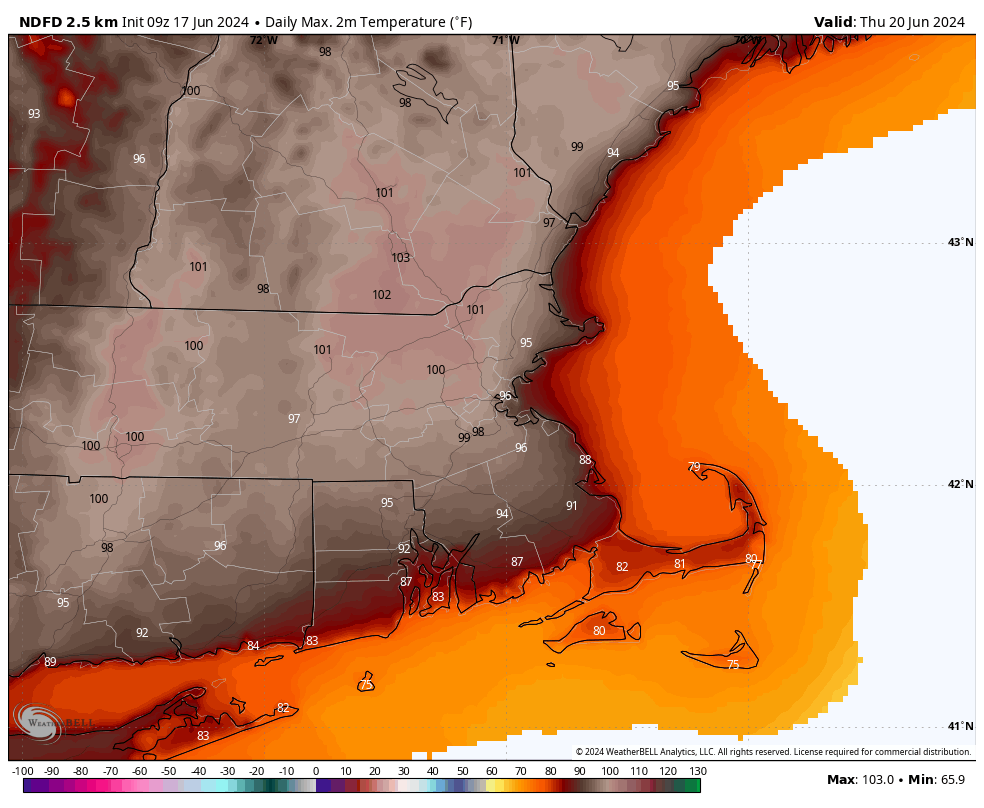
A warm front will cross the region today with just some clouds accompanying it, but little to no precipitation. Behind it, south to southwest winds will usher warmer and more humid air in, and it will remain in place for a good chunk of the week. High pressure building in both at the surface and aloft will result in partly to mostly sunny skies with hot and humid conditions from Tuesday into at least Thursday. The south winds will keep the South Coast and Cape Cod cooler, only in the 80s or even upper 70s, but inland temperatures will get well into the 90s, but when you factor in the humidity, it will feel like 95-105 degrees during the hottest part of the day each afternoon. Air temperatures could approach 100 both Wednesday and Thursday afternoon, especially from MetroWest into the Merrimack Valley, with some records possible. Excessive Heat Watches and Heat Advisories are already in effect for parts of the region from Tuesday afternoon into Friday evening. A few showers and thunderstorms may pop up each afternoon, especially Thursday, but they will be widely scattered, and only provide some relief in a few spots.

Thursday is looking like the hottest day in quite some time across the region. Image provided by WeatherBell.

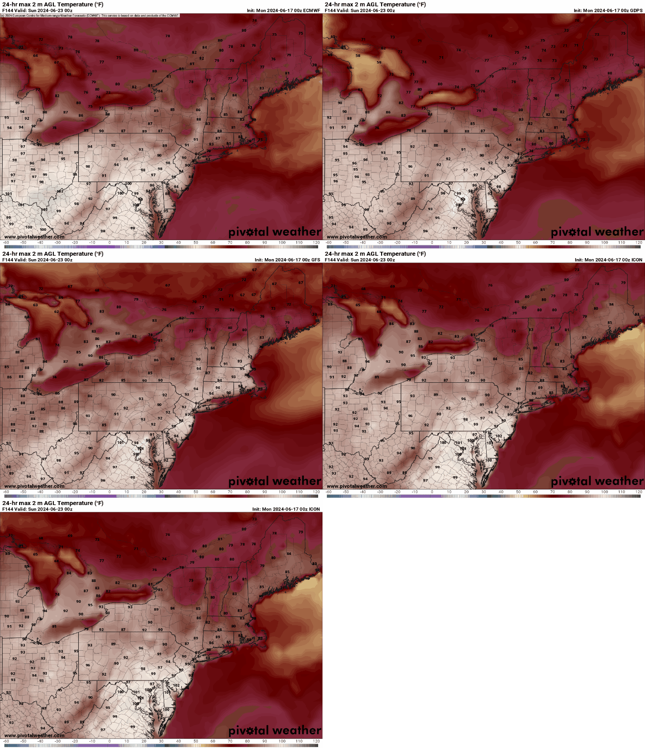
By the end of the week, a cold will start to drop down from the north, bringing more widespread showers and thunderstorms along with cooler weather, but when it moves through is still a question mark. Some models bring it down on Friday, have it lift back northward later Saturday, others have it move through on Friday, then not come back until early in the following week. This will obviously have a big impact on the temperature forecast, especially for the weekend. Some showers will likely accompany this front as waves of low pressure ride along it, but timing them is a fool’s errand at this point, because we’re not even sure yet when the front will move through.

Not all of the models have cooler air move in for Saturday. Images provided by Pivotal Weather.

Monday: A mix of sun and clouds, breezy during the afternoon. High 78-85, a little cooler near the South Coast.

Monday night: Clear to partly cloudy. Low 61-68.

Tuesday: Partly to mostly sunny. High 90-97, except 82-89 near the South Coast and 74-81 across the Cape and Islands.

Tuesday night: Clear to partly cloudy. Low 64-71.

Wednesday: Sunshine and a few clouds. High 93-100, except 85-92 near the South Coast and 77-84 across the Cape and Islands.

Thursday: Partly sunny. High 95-102, except 87-94 near the South Coast and 79-86 across the Cape and Islands.

Friday: Intervals of clouds and sun with some showers and thunderstorms possible. High 90-97, except 82-89 near the coast.

Saturday: Partly sunny, chance for an afternoon shower or thunderstorm. High 84-91, cooler near the coast.

Sunday: Intervals of clouds and sun, showers and thunderstorms possible. High 80-87, cooler near the coast.

Weekend Outlook: June 14-17, 2024

The weekend is going to start off unsettled, but the rest of it looks terrific.

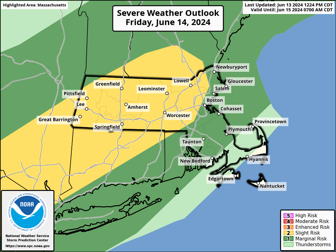
Strong to severe thunderstorms are expected on Friday, especially north and west of Boston. Image provided by the Storm Prediction Center.

High pressure will slide offshore tonight and Friday, with southwest winds bringing warm and increasingly humid air into the region. A cold front will approach from the west during the day on Friday. A line of showers and thunderstorms will develop ahead the front. Conditions should be ripe for some of these storms to become strong to severe during the afternoon and evening, especially north and west of Boston. Some of the storms produce hail and strong winds, with heavy downpours also likely. As the storms move into the Boston area and southeastern Massachusetts they should start to weaken, but some gusty winds and heavy downpours are still possible. The front moves offshore at night, bringing an end to the showers and storms, though they may not end completely until close to daybreak across parts of the Cape and possibly southeastern Massachusetts. High pressure then builds back in for Saturday and Sunday with cooler and drier air. By Monday, the high will move off to the east and warmer and more humid air will start to move back in. This will be the beginning of what looks like a hot week , but we’ll get into more details on that in our Weekly Outlook Sunday night.

The latter half of next week is looking hot around here. Image provided by Weathermodels.com

Thursday night: Clear skies, some clouds may start to drift in late at night. Low 60-67.

Friday: Morning sun, then clouds move in with shower and thunderstorms developing in the afternoon, some could be strong to severe, becoming breezy in the afternoon. High 80-87, little cooler across Cape Cod.

Friday night: Mostly cloudy with showers and thunderstorms ending from northwest to southeast. Low 57-64.

Saturday: Becoming mostly sunny and less humid. High 71-78, coolest near the coast.

Saturday night: Clear skies. Low 48-55.

Sunday: Sunshine and some afternoon clouds. High 72-79, a little cooler at the coast with afternoon seabreezes.

Sunday night: Partly cloudy. Low 53-60.

Monday: A mix of sun and clouds. High 77-84, a little cooler across the South Coast and Cape Cod.

Weekly Outlook: June 10-16, 2024

Much of the upcoming week will feature some rather nice weather for mid-June.

Average high temperatures for mid-June are in the middle 70s across the region. Image provided by Weathermodels.com

We start the week with an upper-level low pressure area still influencing our weather for Monday and Tuesday. We’ll start both days with sunshine, but clouds will develop with a few widely scattered showers popping up each afternoon, then dissipating after sunset. Temperatures will remain a little below normal for mid-June. High pressure builds in Wednesday with drier and seasonably warm conditions. As the high slides offshore on Thursday we’ll start to turn warmer. A cold front will approach the region on Friday. Ahead of it we’ll turn even warmer with a few places possibly approaching 90 degrees. Humidity levels will also be on the increase, though we’re not expecting mid-summer humidity – dewpoints will get into the lower to perhaps middle 60s. As that front moves in, we’ll have some showers and thunderstorms move in late Friday and Friday night. The timing of the front will determine whether or not we’re looking at some severe weather. We’ll have a better idea if that is the case when we get to our Weekend Outlook on Thursday. The front moves offshore by Saturday morning, then high pressure builds back in with cooler and drier weather for the weekend.

Friday is looking like the warmest day of the week. Image provided by WeatherBell.

Monday: Sunshine and some afternoon clouds, slight chance for a shower. High 70-77.

Monday night: Clear to partly cloudy. Low 51-58.

Tuesday: A mix of sun and clouds, a stray shower is possible. High 70-77.

Tuesday night: Clear to partly cloudy. Low 54-61.

Wednesday: Partly to mostly sunny. High 73-80, coolest at the coast.

Thursday: Sunshine and a few clouds. High 80-87, cooler across the South Coast.

Friday: Partly sunny, showers and thunderstorms likely late in the day and at night. High 84-91, cooler across the South Coast.

Saturday: Becoming mostly sunny. High 75-82.

Sunday: Partly to mostly sunny. High 75-82.

Weekend Outlook: June 7-10, 2024

If you’re looking for perfect summer weather this weekend, you’ll be disappointed, but it won’t be as bad as your weather app is showing.

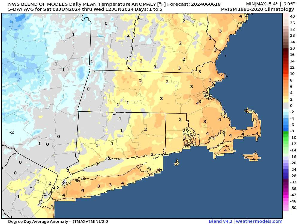
Overall, temperatures will be a little above normal over the next few days. Image provided by Weathermodels.com

A cold front will move in from the west this evening, bringing with it another round of showers and perhaps some thunderstorms as well. Beyond that, an upper-level low will drift in from the Great Lakes and sit across the Northeast through the weekend. That will keep us cooler than recent days and unsettled as well. We’re not expecting any of the days to be a washout this weekend, but what you can expect is plenty of clouds (with some sunny breaks), and daily episodes of showers, perhaps a few thunderstorms, as impulses of energy rotate around that upper low.

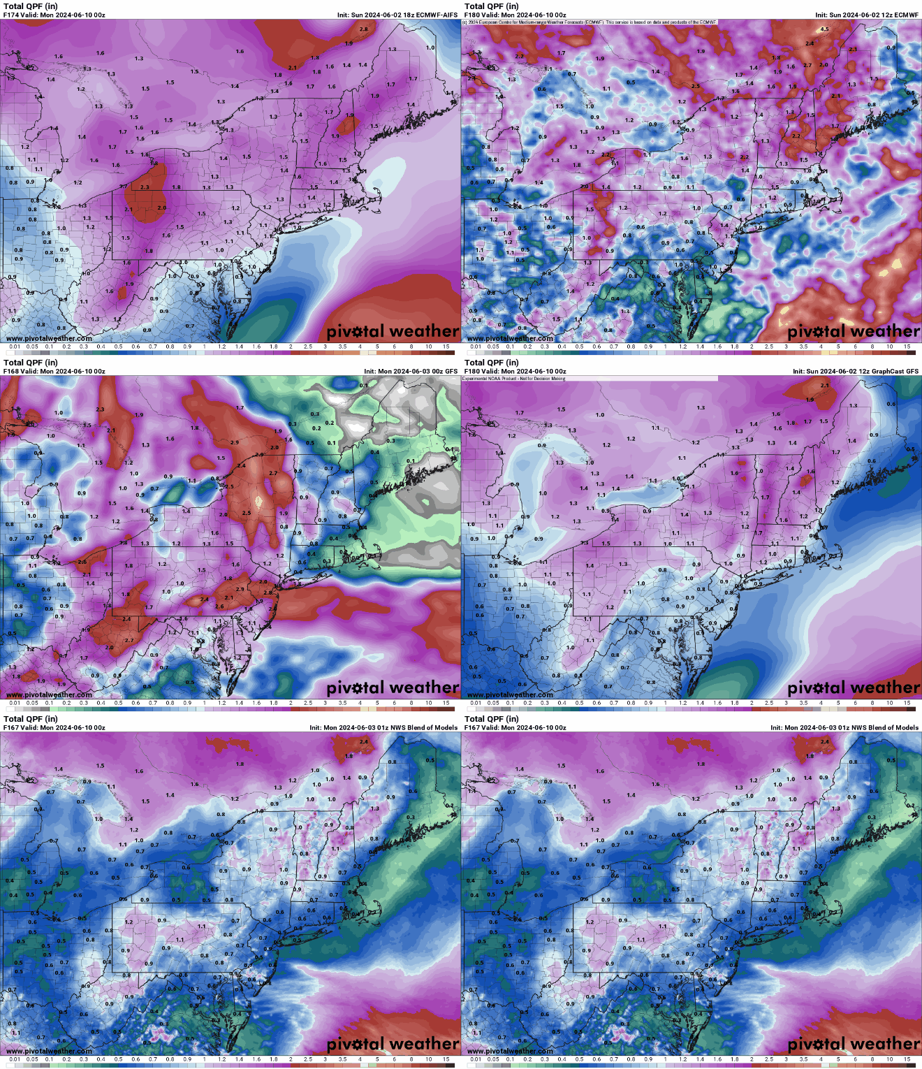
Some models show the potential for a few downpours over the next few days, but for the most part, precipitation totals should be on the lighter side. Images provided by Pivotal Weather.

Thursday night: A few showers possible this evening, followed by some late night clearing. Low 57-64.

Friday: A sunny start to the day, then clouds move back in during the afternoon, just a slight chance for a shower. High 77-84.

Friday night: Clear to partly cloudy. Low 53-60.

Saturday: Partly sunny, breezy, slight chance for a shower. High 71-78.

Saturday night: Partly cloudy, chance for some showers. Low 53-60.

Sunday: Intervals of clouds and sunshine, chance for a few showers, mainly in the morning. High 70-77.

Sunday night: Partly cloudy, chance for a shower or two. Low 52-59.

Monday: A mix of sun and clouds, slight chance for a shower. High 69-76.

Weekly Outlook: June 3-9, 2024

Our stretch of nice weather will continue for a few more days, but changes are coming.

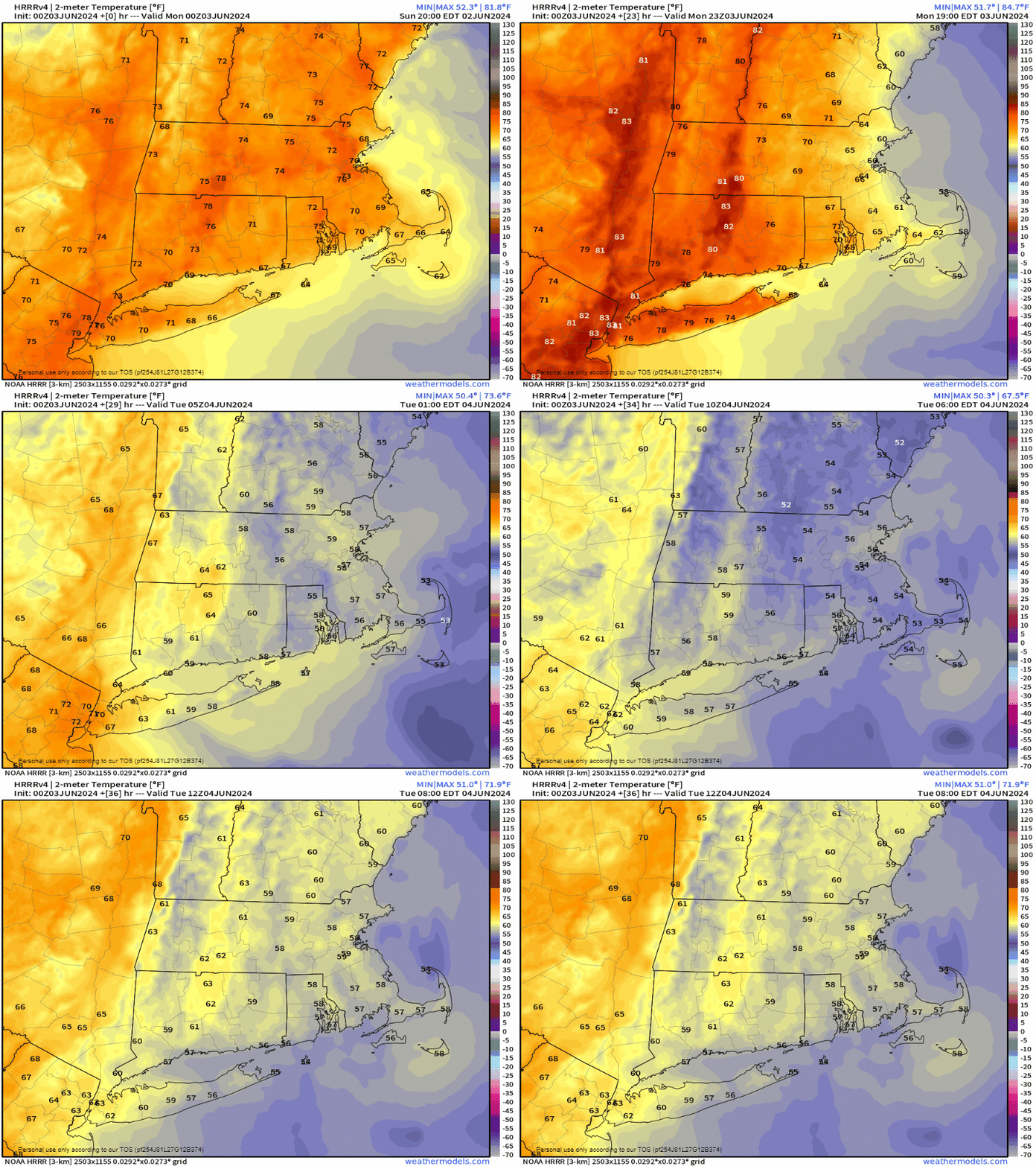
A backdoor cold front brings much cooler air in this afternoon and evening. Loop provided by Weathermodels.com

A weak disturbance passes by early in the day with some clouds and possibly a stray shower or two, otherwise, high pressure remains in control today with mainly dry conditions, but a backdoor cold front will bring some cooler weather into eastern parts of the region during the afternoon. High pressure remains in control for Tuesday with more sunshine and seasonably warm temperatures, though a seabreeze will keep coastal areas cooler. Wednesday is when the transition starts. An upper-level low starts to move out of the Midwest, sending clouds in, but we’ll remain warm, though a seabreeze is likely at the coast once again. A warm front approaches Wednesday night with showers developing, possibly a period of steady rain early Thursday. A second disturbance follows for Thursday night into Friday with another round of showers possible. With the cloud cover and rainfall, temperatures will be cooler, but probably still close to normal for early June. As the upper-level low moves through on Saturday, some additional showers are likely, possibly lingering into Sunday as well, depending on how quickly the upper-level low pressure area moves away from the region.

All of the models have a decent amount of rain in here for the end of the week, but some have quite a bit more than others. Images provided by Pivotal Weather.

Monday: Slight chance for a morning shower, then becoming mostly sunny. High 79-86 inland, 71-78 along the coast but dropping in the afternoon.

Monday night: Partly cloudy. Low 50-57.

Tuesday: Sunshine and some afternoon clouds. High 65-72 along the coast, 73-80 inland.

Tuesday night: Partly cloudy. Low 52-59.

Wednesday: Partly sunny, rain may develop late in the day, more likely at night. High 77-84, cooler along the coast.

Thursday: Mostly cloudy with some showers possible, especially in the morning. High 69-76, coolest near the coast.

Friday: Intervals of clouds and sun, chance for a few showers. High 70-77.

Saturday: Partly sunny, chance for a few more showers. High 69-76.

Sunday: A mix of sun and clouds, slight chance for another shower. High 70-77.