Better enjoy these next two days, because much of this week won’t be that great.

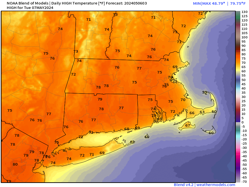
An upper-level disturbance pulls away from the region this morning, bringing an end to any lingering showers, then skies will start to clear out, with much milder air moving in. A weak front dropping down from the north may trigger a few showers or even a thunderstorm this afternoon, but they’ll be brief and not that widespread. Tuesday is most certainly the pick of the week. High pressure builds in with lots of sunshine, allowing temperatures to get well into the 70s, though coastal locations will be much cooler as a seabreeze kicks in. With water temperatures still only in the 40s to lower 50s, places right at the shoreline will drop back to the 50s during the afternoon.
Low pressure moves into the Great Lakes on Wednesday, sending a frontal boundary towards the region. We’ll see some showers developing, with cooler air starting to move back in. That front will stall out and we’ll see waves of low pressure riding along it for Thursday and Friday, producing more showers while likely keeping temperatures quite chilly for early May. South of that front, temperatures will be quite a bit milder. It could lift northward at times, bringing that milder air back into parts of Rhode Island and southeastern Massachusetts, while the rest of the region stays rather cool, but picking out when (or if) that will happen several days in advance is not that simple. It won’t be raining the entire time, and neither day will likely be a washout, but it won’t exactly be beach weather either. There are some indications that high pressure may try to build in for later Saturday and Sunday with drier air and improving weather, but other models want to keep low pressure nearby with more rain and cool conditions. We’re going to be cautiously optimistic for now, but should have a better idea when we publish our Weekend Outlook Thursday afternoon.

Monday: Any lingering showers end early, then becoming partly sunny, another shower or thunderstorm possible late in the day. High 69-76, cooler across Cape Cod.
Monday night: Gradual clearing. Low 48-55.
Tuesday: Sunshine and a few clouds. High 70-77, cooler at the coast.
Tuesday night: Clear during the evening, clouds start to move in overnight. Low 45-52.
Wednesday: Mostly cloudy with some showers likely. High 59-66, coolest at the coast.
Thursday: Mostly cloudy and breezy with more showers. High 58-65, a little cooler at the coast.
Friday: Breezy and cool with a chance for some additional showers. High 52-59.
Saturday: Intervals of clouds and sunshine, breezy, chance for a few more showers. High 53-60.
Sunday: Partly sunny, breezy, slight chance for a shower. High 58-65, coolest at the coast.
