Our first sign that winter is on its way out arrives today. No, we’re not talking about the groundhog. It’s Truck Day, the day that the equipment truck leaves Fenway to head to Fort Myers for the beginning of Spring Training next week.

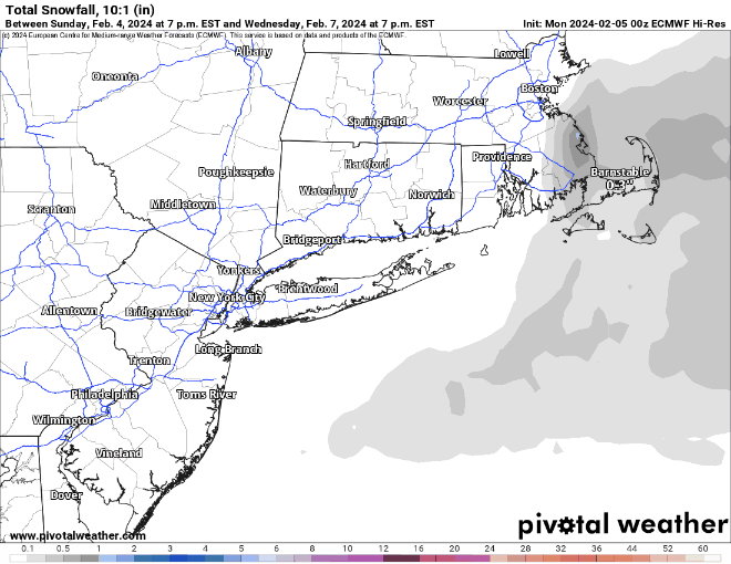
In terms of weather, we start the week with more sunshine as high pressure remains in control. Tuesday and Wednesday should end up decent for a good portion of the region, but it could be a little complicated. High pressure will remain in place across southeastern Canada. The low pressure system that produced severe weather across Florida on Sunday will slowly move into the Atlantic, passing well south and east of New England. We’ve also got an upper-level low spinning south of Atlantic Canada. The pressure gradient between the high to the north and low to the south will result in some gusty northeast winds, especially near the coast Monday night into Wednesday. They’ll also bring in some cloud cover, especially across southeastern Massachusetts. Meanwhile, disturbances rotating around that upper-level low well to the east will bring in a little more cloud cover on Tuesday, and possibly a few snow showers, especially along the coast, and south of Boston. It wouldn’t be a shock if the ground got covered across parts of southeastern Massachusetts and Rhode Island, and a few of these ocean-effect snow bands could even produce an inch or two across coastal Plymouth County and Cape Cod.
We should clear out later Wednesday, but clouds will start to move back in on Thursday as a frontal system starts to approach the region from the west. Temperatures will warm to above normal levels for the end of the week, with temperatures possibly topping 50 across parts of the region on Friday. Some showers are likely Friday night into Saturday ahead of the front. Temperatures will drop a few degrees on Sunday but it will remain mild with more clouds expected.

Monday: Plenty of sunshine, clouds start to move in late in the day, breezy. High 35-42.
Monday night: Partly to mostly cloudy, some snow showers possible south of Boston, breezy along the coast. Low 20-27.
Tuesday: Plenty of clouds, some sunny breaks well inland, more snow showers south of Boston, breezy near the coast. High 32-39.
Tuesday night: Partly to mostly cloudy more snow showers possible, mostly across eastern Massachusetts, breezy along the coast. Low 22-29.
Wednesday: Morning clouds and a few more snow showers across eastern Massachusetts, skies start to clear out in the afternoon, still breezy near the coast, especially in the morning. High 35-42.
Thursday: Sunshine and some afternoon clouds. High 38-45.
Friday: Becoming mostly cloudy, breezy. High 41-48.
Saturday: More clouds than sun, breezy. High 49-56.
Sunday: Partly sunny, breezy. High 46-53.
