Cold weather is on the way out, but wet weather may be on the way back in.

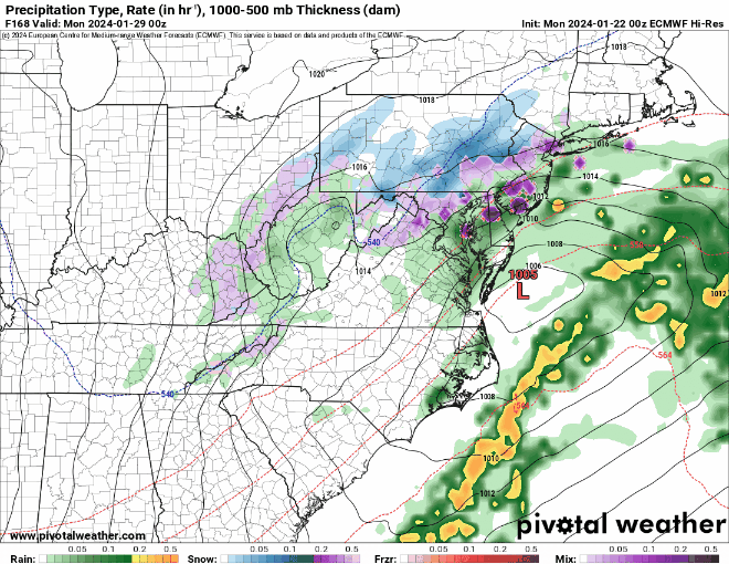
We start the week off with high pressure sliding offshore to our south, which means moderating temperatures today with sunshine for part of the day, but we’ll see some clouds start to move in by evening. A cold front will drop down from the north on Tuesday with more clouds, but as a wave of low pressure rides along with, we may see a period of light snow Tuesday night into early Wednesday. Accumulations will be on the light side, generally a few inches at most. By later Wednesday, that front will lift northward as a warm front, changing the snow to rain across the region as the precipitation tapers off.

Another wave of low pressure brings in a second bout of rain for Wednesday night into Thursday, with temperatures warming to above normal across the region. Yet another wave of low pressure could bring in more rain for Friday, before high pressure builds in with drier weather on Saturday. Sunday is highly uncertain at this point. Another cold front will be dropping down from the north while a developing low pressure area moves off the Mid-Atlantic coast. Does the low stay too far south to have any impact on us, does it come farther north and bring in some snow or rain? We can’t answer this question yet, but hope to have more clarity when it is time for our Weekend Outlook Thursday afternoon.
Monday: Sunny in the morning, some clouds start to move in during the afternoon. High 33-40.
Monday night: Partly to mostly cloudy, breezy, slight chance for a snow flurry. Low 26-33.
Tuesday: Some sunny breaks in the morning, otherwise mostly cloudy, some light snow possible toward evening. High 35-42.
Tuesday night: Cloudy with some light snow developing. Low 26-33.
Wednesday: Cloudy with light snow tapering off early, eventually changing to sleet and then rain showers. Some steadier rain expected at night, possibly still as freezing rain across central New Hampshire. High 34-41.
Thursday: Cloudy with occasional light rain and showers. High 42-49.
Friday: Mostly cloudy, breezy, more rain, especially in the morning. High 47-54.
Saturday: Partly to mostly cloudy. High 43-50.
Sunday: Partly sunny, breezy, chance for some snow or rain showers, mainly near the South Coast. High 37-44.
