The first snowstorm of the season has pulled away, but we’re already looking ahead to two more potent storm systems later this week.

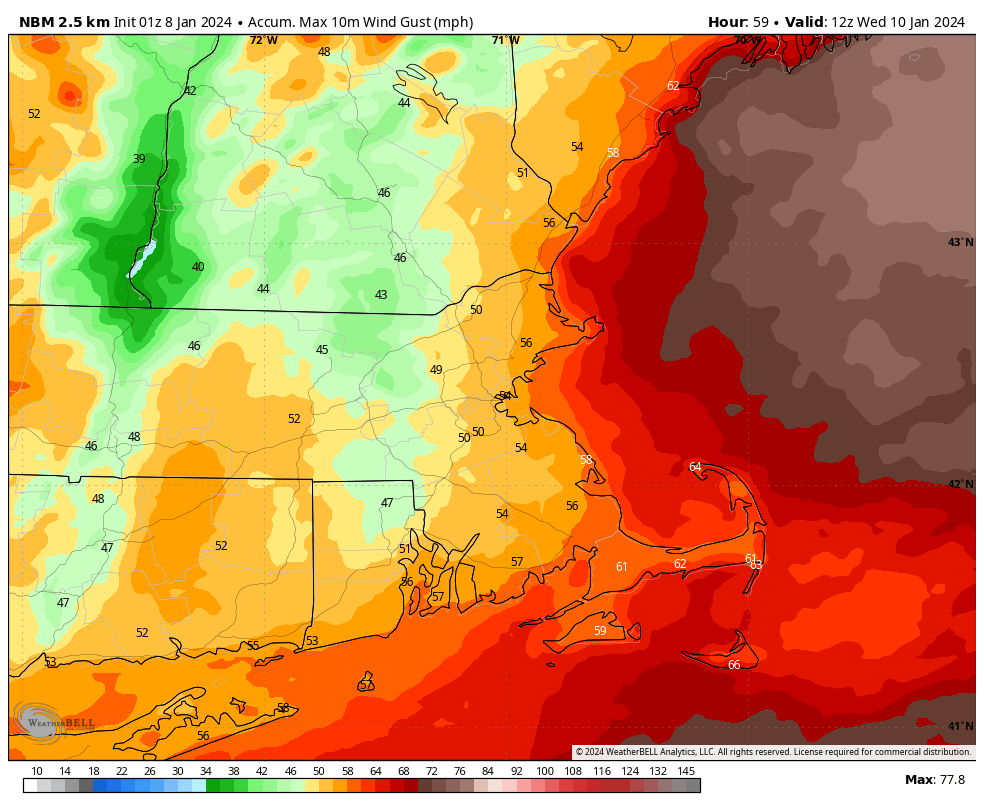
High pressure builds in today with dry and rather chilly conditions, thanks to the fresh snowcover. Tuesday starts off dry as well, but a strong storm system will head toward the Midwest, spreading clouds in. Temperatures will still be chilly, so when the precipitation moves in late in the day, it may start as snow or a wintry mix across the interior, with some accumulation possible. However, it won’t last too long. As the systems gets all wound up, strong southerly winds both at the surface and especially aloft will bring much warmer air into the region, changing everything to rain. Sustained winds of 15-25 mph with gusts of 40-50 mph are possible inland with the storm, but along the coast, we could be looking at sustained winds of 25-35 mph with gusts upwards of 50-60 mph or higher. This could lead to trees and power lines coming down with power outages a significant concern. Tides will be astronomically low, so the risk for coastal flooding is fairly low as well. The biggest problem aside from the winds will be heavy rain. Many areas could pick up 1-2 inches of rain or more. While this could lead to areas of flooding on its own, combine that with significant melting of the snow on the ground, and you’ve got a recipe for widespread flooding. We’ll see if that materializes over the next couple of days.
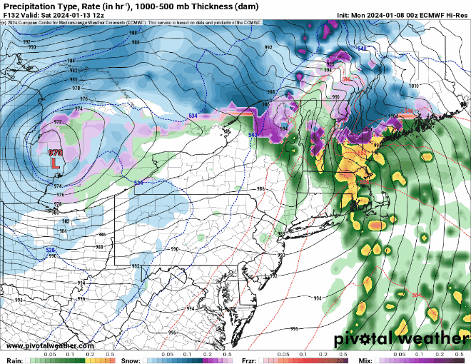
Rain ends early Wednesday, followed by windy and colder conditions during the day as the system moves across southeastern Canada. High pressure builds in for Thursday with diminishing winds. By Friday, another potent system moves into the Great Lakes, but things are a little more uncertain with this one. We could see a secondary low pressure system develop across the Mid-Atlantic states and head towards southern New England. If this does develop, then a colder scenario with at least some snow across the interior becomes more likely for Friday night into Saturday. If it doesn’t, then we’ll likely be looking at more rain, which could worsen flooding across the area. Another weak system could move through late Sunday with some snow showers possible.
Monday: Plenty of sunshine, breezy during the morning. High 32-39.
Monday night: Clear skies, a few clouds move in late at night. Low 12-19.
Tuesday: Becoming mostly cloudy with rain developing late in the day from Boston southward, snow north and west. Winds start to pick up late in the day. High 34-41.
Tuesday night: Cloudy and very windy with everything becoming all rain, heavy at times. Low 31-38 during the evening, temperatures rise overnight.
Wednesday: Cloudy and windy with rain ending in the morning, skies start to clear out during the afternoon. High 50-57 early, temperatures start dropping in the afternoon.
Thursday: Mostly sunny, breezy, colder. High 38-45.
Friday: Morning sunshine followed by increasing afternoon clouds, rain developing at night, possibly starting as snow well inland. High 39-46.
Saturday: Mostly cloudy and windy with rain ending in the morning, some clearing possible late in the day. High 50-57.
Sunday: Partly sunny, windy, colder, a few late-day snow showers possible. High 34-41.
