We’re less than 24 hours away from the first snowstorm of the year for most of the region, and while not a blockbuster, it will still have a sizable impact on the region.

Low pressure will move across the Southeast and off the Mid-Atlantic coastline later today and tonight, passing south of New England on Sunday. Meanwhile, high pressure over Quebec will move into Atlantic Canada. While this high will provide cold air to start, due to its position and movement, combined with low pressure to the south, we’ve have gusty east winds across much of the region, possibly gusting to 30-40 mph or higher along the coast. With water temperatures still in the lower to middle 40s, this will mean that places close to the coastline will likely be rain or a mix to start. This includes parts of Cape Ann, the North Shore, Boston, and most of the South Shore, Cape Cod, and Southeastern Massachusetts. We’ll have a few flurries or sprinkles around this afternoon, but the steadier precipitation should move in between 6 and 9 pm. The precipitation may fall heavy at times overnight, but by daybreak winds will become more northeasterly, and eventually northerly towards midday. This will allow colder air to slide southward, changing the rain over to snow along the coast as well. This will also allow any untreated roads to rapidly ice up, so be careful if you will be out and about. The snow should eventually end during the evening, with winds rapidly diminishing overnight.

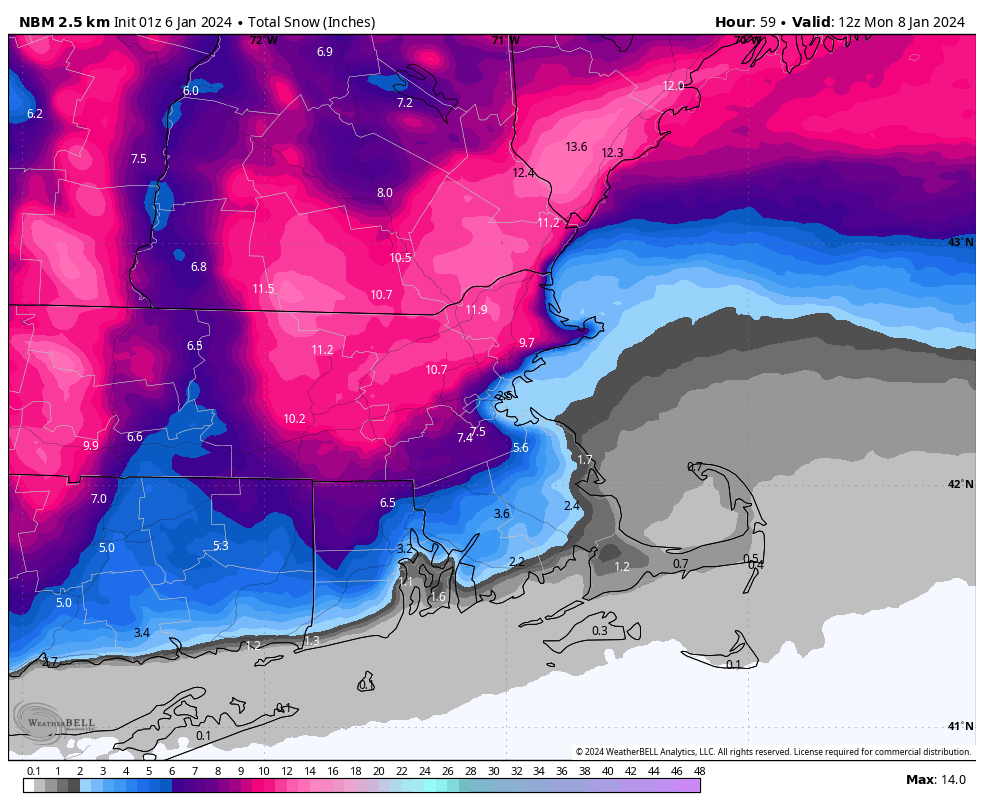
So, how much snow are we expecting? Well, if you read our initial forecast in the Weekend Outlook, we’re bumping numbers up a bit.
Cape Cod: Coating to 2 inches.
Southeastern Massachusetts: 2-5″
I-95 corridor (Boston to Providence) and immediate North Shore: 4-7″
MetroWest/Merrimack Valley/Interior Essex County/Southern NH: 5-10″ isolated totals of 12″+
We’ll clear out for Monday with chilly temperatures, due to the fresh snowcover. Another system follows for late Tuesday and Wednesday, and while this one may have some snow to start, it will end up much warmer with strong winds and heavy rain being the main concerns.
