Your luck has run out. Our first snowstorm of the winter is on the way this weekend.

High pressure builds in for tonight and Friday, with clearing skies, breezy, and colder conditions. Clouds star to move back in Friday night and Saturday as low pressure moves across the Deep South and into the Southeast. It’ll move up the coast on Saturday, likely passing south of the region on Sunday, while high pressure in southern Quebec slides off to the east. There is still some uncertainty as what exactly will transpire, so some of the next paragraph is subject to change.
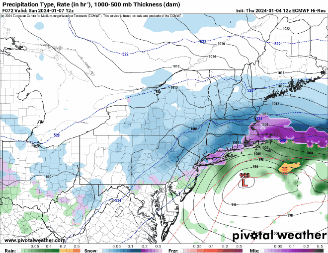
While the high over southern Quebec will provide us with plenty of cold air to start, it’s not in the perfect position to provide the region with enough cold air to keep everything all snow, especially near the coastline. Winds will be out of the east, allowing milder air to move in off of the relatively mild Atlantic. (To get mostly snow, you want to high to be a little farther west, so you get northeast winds across our area). There is also still some uncertainty as to exact track the low pressure area takes and how close it gets to the coastline, which will also lead to some rain in spots, especially near the coast. We should see the snow developing Saturday evening, likely starting as a mix or even just plain rain along the coast from Boston southward since winds will be out of the east. Snow will continue through the night, but it may stay rain or a mix right along the immediate coastline for a while. By mid-morning Sunday, as the low passes by, winds will shift from the east into the north, allowing the cold air to push back in, changing everything to all snow, even across Cape Cod and the Islands before everything winds down by evening. The rain and milder temperatures keep accumulations lower near the coast, but inland, this will not be a blockbuster storm, as the snow , while falling for a while, will only be light to occasionally moderate for most of the time. So, how much are we looking at?
Cape Cod: Coating – 2″
I-95 corridor (Boston-Providence and points South+East): 2-5″, lowest along the coast
Areas North+ West of I-95: 4-8″ with isolated totals to 10″ possible.

Everything winds down Sunday night, and high pressure builds back in for Monday with sunshine and seasonably chilly conditions.

Thursday night: Clear skies, breezy. Low 17-24.
Friday: Plenty of sunshine, breezy during the morning. High 29-36.
Friday night: Partly cloudy. Low 20-27.
Saturday: Becoming mostly cloudy. High 32-39.
Saturday night: Snow developing, mixed with or changing to rain along the coast, becoming windy. Low 25-32 during the evening, temperatures hold steady or rise a bit overnight.
Sunday: Windy with snow likely, except rain or mix changing to snow along the coast by midday. High 32-39, temperatures rapidly drop along the coast in the afternoon.
Sunday night: Any lingering snow ends in the evening, some clearing late at night, winds rapidly diminish during the evening. Low 13-20.
Monday: Becoming mostly sunny. High 31-38.
