We’ve got another complicated forecast coming up for the start of the weekend, but the end isn’t complicated at all.

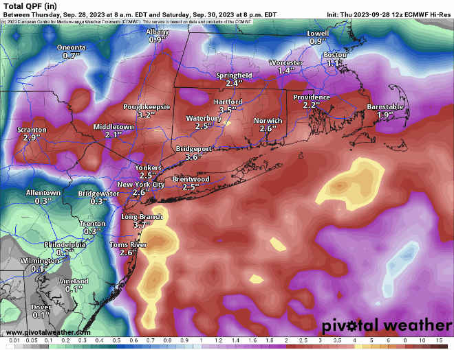
High pressure will remain in place across southeastern Canada through the weekend. An upper-level low will move from the Great Lakes toward the Northeast, keeping us on the cool side through Saturday. A disturbance rotating around that low will help spawn a low pressure system off the Mid-Atlantic coastline, where there is still plenty of moisture hanging around, some of it being the remains of Ophelia. While the low should stay well to our south, a trough extended from the low towards southern New England will help draw some of that moisture northward, generating plenty of clouds tonight and Friday. The question becomes, how far north does the rain get, and how heavy will it be. There is still a lot of disagreement among the models, but based on the trends in the models and their known biases, we’re thinking that most of the rain will be south of the Mass Pike, with the steadiest and likely heaviest rain mainly south of Route 44. It wouldn’t be a surprise if no rain falls at all from the Merrimack Valley into southern New Hampshire. The rain winds down Saturday morning, and we may see some clearing by late in the day. After that, high pressure builds back in for Sunday and Monday with sunshine and warmer temperatures.
Thursday night: Becoming mostly cloudy, patchy fog may develop once again. Low 46-53.
Friday: Mostly cloudy with showers developing, mainly south of the Mass Pike. High 60-67.
Friday night: Cloudy with periods of rain and showers, mainly south of the Mass Pike. Some of the rain could be heavy near the South Coast. Low 50-57.
Saturday: Showers ending around midday, some breaks of sun possible by late afternoon, especially from the Merrimack Valley northward. High 62-69.
Saturday night: Clearing. Low 49-56.
Sunday: Plenty of sunshine. High 68-75.
Sunday night: Clear to partly cloudy. Low 52-59.
Monday: Sunshine and a few clouds. High 67-74.
