All eyes are on Hurricane Lee and what impact it will have on the region over the next few days.
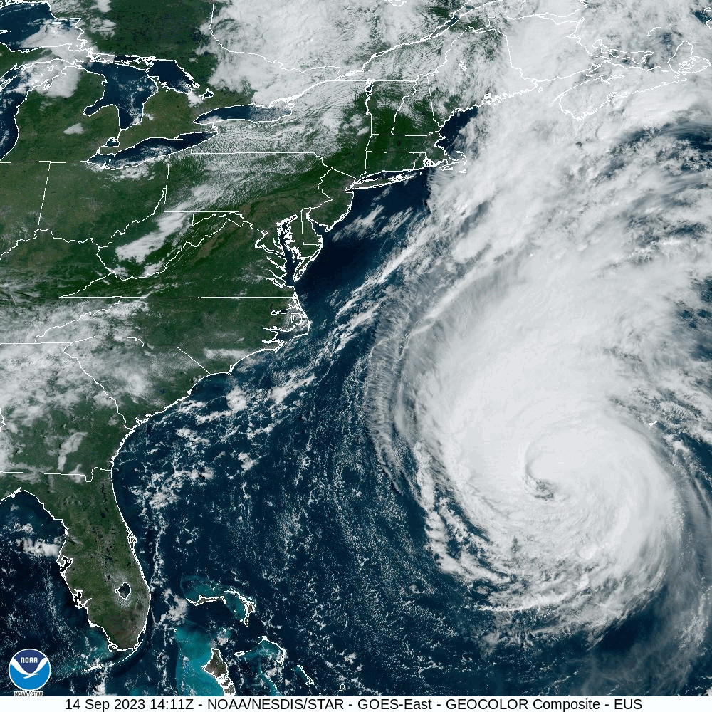
Hurricane Lee was centered about 710 miles south of Nantucket at 2pm, moving toward the north at 14 mph. Maximum sustained winds were near 85 mph. A Tropical Storm Warning is in effect for Cape Cod and the Islands as well as coastal Plymouth County, with a Tropical Storm Watch for the rest of Massachusetts and Rhode Island, as well as the Seacoast of New Hampshire and the southern Maine coastline. A Storm Surge Watch is also in effect for Cape Cod Bay and Nantucket. Lee will continue northward for the next 24 hours, gradually weakening as it feels some increasing wind shear and starts to move over cooler waters. A slightly bend toward the northwest is possible late Friday as an upper-level low moves into southern Canada, but it should eventually start to turn more toward the northeast, likely becoming extratropical as it makes landfall in Nova Scotia at tropical storm strength.
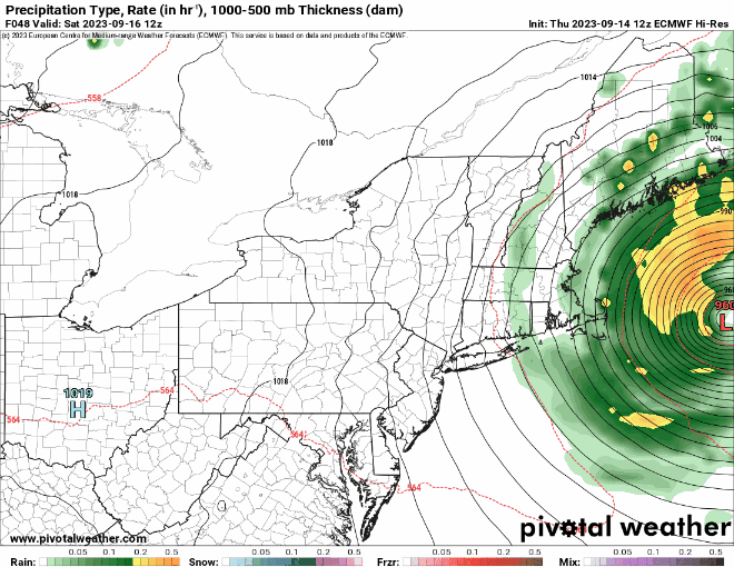
High clouds ahead of Lee will stream into the region tonight, and they will thicken up on Friday as winds start to increase as the pressure gradient between and a high pressure area to our northwest tightens up. The worst of the storm will be between Midnight and about Noon on Saturday. Most of the rain will be confined to Cape Cod and the immediate coastline, with just a few showers penetrating farther inland. With northeast to northerly winds, eventually become northwest Saturday afternoon, the only places where storm surge will be an issue is north-facing shorelines, where the Storm Surge Watch is in effect. While large waves will batter the coastline for the next few days, a storm surge of 2-4 feet above the normal tides will impact the north shore of Cape Cod and northern Nantucket. As for those winds, we’re looking at sustained winds of 30-50 mph for parts of Cape Cod and the Islands with gusts to 60 mph or more, and 20-30 mph sustained winds near the eastern Massachusetts coast with gusts of 40-50 mph possible. Farther inland, winds will be a little weaker than that. Overall, Saturday will be a windy day, with some rain mainly near the coast, something we’ve experienced hundreds, if not thousands, of times. In the grand scheme of things, this is not a big deal for 95% of our region.

Once Lee starts to pull away, skies will clear out Saturday night and winds will start to diminish, setting up a fantastic Sunday with sunshine and warm temperatures. Clouds will start to move back in by evening as a weak disturbance starts to approach from the west. That system may produce a few showers on Monday, but temperatures will remain mild.
Thursday night: Increasing clouds. Low 51-58.
Friday: Mostly cloudy, becoming breezy. High 65-72.
Friday night: Cloudy and windy with showers developing near the coast, some steadier and heavier rain across Cape Cod. Low 54-61.
Saturday: Windy with rain and showers ending around midday, skies may start to clear out late in the day. High 65-72.
Saturday night: Clearing with diminishing winds. Low 53-60.
Sunday: Sunshine and some afternoon clouds, still breezy in the morning. High 72-79.
Sunday night: Becoming partly to mostly cloudy. Low 55-62.
Monday: Intervals of clouds and sun with a chance for a few showers. High 71-78.
