Meteorological summer ended last Thursday. Pumpkin everything has arrived, college football has begun, the NFL starts the regular season this week, kids are back in school, Christmas stuff has even started showing up in stores. Summer is over, right? Astronomical summer doesn’t end until the autumnal equinox, which occurs at 2:49AM on September 23. Mother Nature will remind you this week that it’s still summer.
The forecast for the first half of the week is fairly simple. High pressure will remain in control with sunny days, warm to hot temperatures, coastal seabreezes, and increasing humidity. With the humidity, we’ll also have some patchy fog developing during the next few nights. Temperatures will get well into the 80s during the afternoons, with some spots topping 90, though coastal locations will likely drop into the 70s during the afternoons. The latter half of the week is where things get tricky.

Thursday is likely to be another very warm to hot and humid day, but clouds will be moving in ahead of an approaching frontal system. Some showers and thunderstorms may move in late in the day, but it is just as likely that Thursday remains rain-free. Showers and thunderstorms look more likely on Friday, but temperatures will be highly dependent on the timing of the front. A frontal passage earlier in the day means cooler temperatures, but a later frontal passage could mean another day with temperatures topping 80. Some models don’t show the front moving through until Saturday, which could mean yet another warm day, but also more showers and thunderstorms. The front may stall out nearby, which means the unsettled weather could even linger into Sunday. With the Patriots set to open their season in Foxborough at 4:25pm next Sunday, fans are hoping for nice weather for the game itself and pregame tailgating.

Monday: Patchy morning fog, otherwise sunshine with a few afternoon clouds. High 82-89, cooler along the coast.
Monday night: Partly cloudy, areas of fog develop. Low 61-68.
Tuesday: Becoming mostly sunny. High 84-91, cooler along the coast.
Tuesday night: Clear to partly cloudy, patchy fog possible again. Low 65-72.
Wednesday: Mostly sunny. High 85-92, cooler along the coast.
Thursday: Morning sun, increasing afternoon clouds, showers and thunderstorms possible late in the day. High 87-94, cooler along the coast.
Friday: More clouds than sun with some showers and thunderstorms likely. High 81-88.
Saturday: Partly to mostly cloudy with a chance for more showers and thunderstorms. High 78-85.
Sunday: Intervals of clouds and sun, chance for another shower or two. High 75-82.
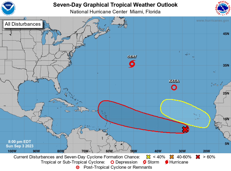
Finally, a word about the tropics. There is a tropical wave way out in the Atlantic that is slowly getting better organized. It could become a tropical depression in the next few days. It is at least 5 days away from potentially impacting the islands in the eastern Caribbean, if at all, and assuming it actually develops. There have been a few of the forecast models that have been showing that this storm could be a threat to the East Coast. At this point in time, that is pure hype and nothing else. These same models have done a horrible job forecasting actual tropical systems this season, let alone ones that haven’t even developed yet. Could this system impact the East Coast? Sure, anything is possible, but that’s a minimum of 8-10 days away from even potentially happening. This is not something you should be too concerned about at this point in time. If there is a time to be concerned, we’ll let you know well in advance. For now, ignore the hype.
