We’re at the end of August, which means we’re entering the peak of hurricane season, and things are active, especially in the Atlantic.
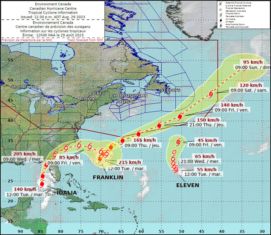
The biggest storm right now is Hurricane Franklin. As of 2pm, Franklin was centered about 330 miles west-southwest of Bermuda, moving toward the north-northeast at 12 mph. After reaching Category Four strength yesterday, maximum sustained winds have decreased to 125 mph today. A Tropical Storm Warning has been issued for Bermuda. Even though Franklin will pass well north and west of Bermuda on Wednesday, it is a large enough storm that tropical storm force winds are expected across the island. Squally conditions with showers and wind gusts of up to 50 mph are expected tonight and Wednesday, along with rough surf, but once past the island, Franklin should continue east-northeastward out into the open waters of the Atlantic while steadily weakening. Franklin will also produce some rough surf and rip currents along the East Coast and into Atlantic Canada, but otherwise will have little impact on land.

The new kid on the block is Tropical Depression 11, which just formed about 855 miles east-southeast of Bermuda. The system has maximum sustained winds of 35 mph and is drifting northward. Wind shear is keeping the storm weak, but it may relax enough later today and tonight to allow for a little strengthening. If it does reach tropical storm strength, it would be given the name Jose. The storm is expected to slowly move northward over open water for the next few days, and by late in the week it should weaken and eventually dissipate without impacting any land areas.

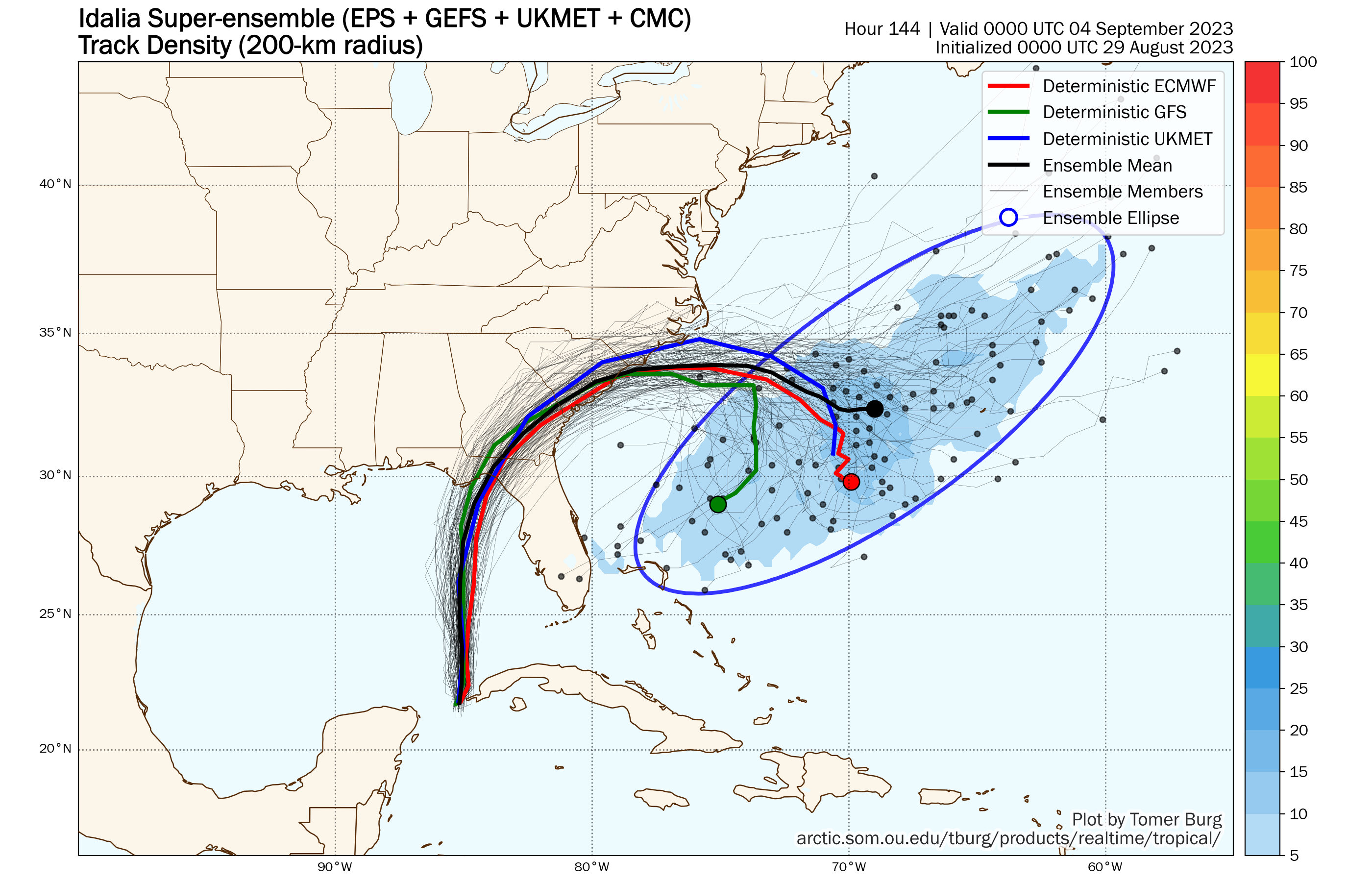
By far, the storm that is the biggest threat is Hurricane Idalia. As of 2pm, Idalia was centered about 240 miles southwest of Tampa, Florida, moving toward the north at 15 mph. Maximum sustained winds were near 90 mph. Idalia is moving over some very warm water in the eastern Gulf of Mexico, and wind shear is low, which likely will result in some rapid strengthening over the next 12-24 hours. Idalia could become a Category 3 or even a Category 4 hurricane before making landfall in Florida’s Big Bend area Wednesday morning. This is one of the least-populated areas of the Florida coast, so that’s at least a little good news. However, significant impacts are expected across much of the region. Storm surge combined with astronomical high tides will result in flooding for much of the Florida west coast, including the Tampa area, but the biggest storm surge, upwards of 10-15 feet, is likely near and to the right of where the center of the storm makes landfall. The strongest winds will be east of the center, with wind gusts of 30-50 mph expected for much of the Florida Peninsula, with stronger winds, gusting to 60-80 mph or higher, likely from the Big Bend and eastern Panhandle, into parts of southern Georgia. The other threat will be heavy rainfall, mainly along and west of the center. From the Florida Panhandle into Georgia and parts of the Carolinas, rainfall totals of 5-10 inches and locally heavier are expected, which will produce flooding in many locations.

While Idalia’s track is fairly straightforward for the next 2-3 days, beyond that, its future is a little murky. It will eventually turn more toward the northeast and east-northeast after landfall, moving back into the Atlantic later this week. How quickly it moves back into the Atlantic will determine how strong it still is at that time. This will also be a factor is determining where the heaviest rainfall is expected across parts of the Carolinas. Once offshore, there is a wide range of model solutions for Idalia’s track. Some have it stall out and sit well offshore, some have it drift towards Bermuda, so have it head out to sea, and some have it turn more toward the south or even southwest, where it could threat the Bahamas or even Florida again. It is far too soon to determine which solution has more validity than any other, but there’s a chance that we may not be done talking about Idalia once it moves away from the Southeast.
The Atlantic isn’t the only active basin right now, with two storms in the Western Pacific that bear watching. Super Typhoon Saola is centered about 340 miles north-northeast of Manila, Philippines, moving toward the northwest at 7 mph. Maximum sustained winds are near 155 mph, and some additional strengthening is possible over the next 24 hours. Saola is expected to head westward, passing north of Luzon but across some of the smaller islands over the next 12-24 hours. After that it will head into the South China Sea, where it may slowly weaken. It could threaten parts of southern China, including Hong Kong later this week, though current forecasts keep the center offshore.

Also in the Western Pacific is Tropical Storm Haikui, centered about 660 miles northwest of Guam, moving toward the west at 7 mph. Maximum sustained winds were near 60 mph, and the system should steadily strength, likely becoming a typhoon in the next day or two. Haikui should continue west-northwestward over open water for the next several days while strengthening. It is several days away from potentially impacting any land areas.

Another system could be developing east of Guam over the next few days, and long-range forecasts show the potential for that system to possibly impact Japan by early next week. We also have Tropical Storm Irwin in the Eastern Pacific Ocean, but it is well west of Mexico over open water and weak, and expected to dissipate over the next few days.
