More rain is on the way, but most of the weekend should end up rather nice.

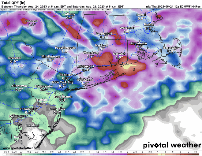
Low pressure is moving across the Great Lakes this afternoon, and it will slowly head eastward, sending clouds into the region today, with rain developing tonight. Friday is looking like a cloudy, breezy, cool, and wet day ahead of the system, with episodes of rain and showers, possibly a few embedded thunderstorms, especially near the South Coast. The system will try to send a warm front across the region, but it doesn’t look like it’ll make too much progress northward, so most of us will stay cool, except areas closer to the South Coast. Some of the rain may be heavy during the day on Friday. The rain will taper off Friday night, but it may not end until Saturday morning, especially across eastern Massachusetts. As a cold front pushes offshore, we’ll see some sunshine develop, but another upper-level disturbance will move across the region, generating some additional clouds, and possibly a few late-day showers. High pressure starts to build in on Sunday, but yet another upper-level disturbance will move through, likely producing more clouds. We’ll have some drier air in place, but there will still be a chance for a stray shower or two as the disturbance moves through. Monday looks like the pick of the weekend with partly to mostly sunny skies and mild temperatures.
Thursday night: Cloudy with periods of rain and showers developing, especially after midnight. Low 58-65.
Friday: Breezy and cool with episodes of rain and showers, some possibly heavy, a few rumbles of thunder are also possible. High 67-74.
Friday night: Mostly cloudy, rain and showers slowly taper off. Low 61-68.
Saturday: Some lingering showers in the morning, then becoming partly sunny, with a few more showers possible late in the day. High 74-81.
Saturday night: Any showers end during the evening, becoming partly cloudy. Low 58-65.
Sunday: A mix of sun and clouds, slight chance for a shower or two. High 69-76.
Sunday night: Clear to partly cloudy. Low 54-61.
Monday: Partly to mostly sunny. High 71-78.
