Stop us if you’ve heard this before – we’ll be dealing with upper-level lows and upper-level troughs of low pressure again this week, with more rain on the way.
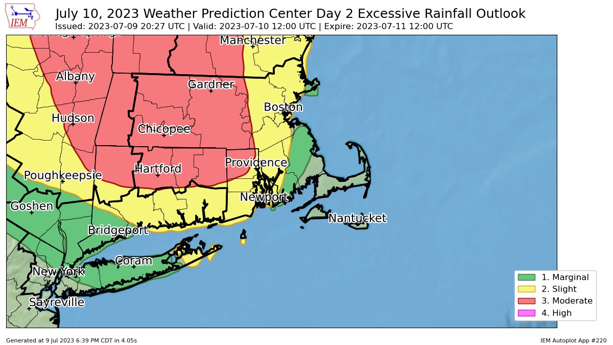
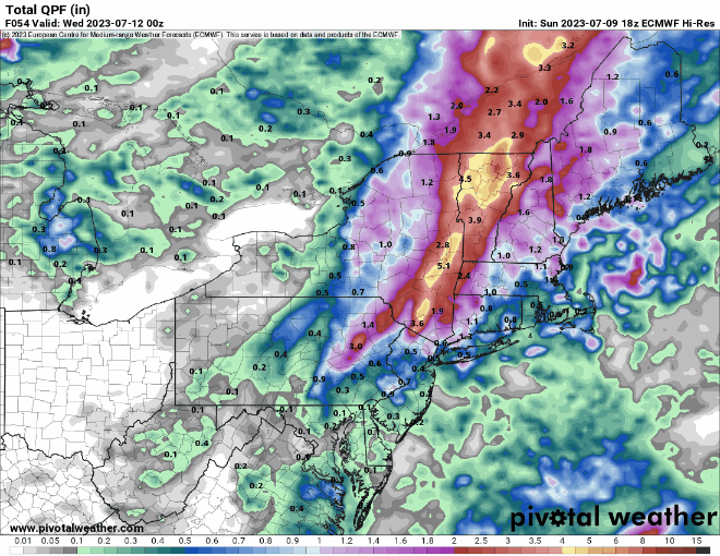
A frontal system will move into the region today while a wave of low pressure rides up along it. This system produced extraordinarily heavy rain across western New England and eastern New York yesterday. While we’ll have some of that heavy and thunderstorms moving in today, it shouldn’t be anywhere near the magnitude of what they experienced across the Hudson and Connecticut Valleys yesterday, where as much as 5-10 inches of rain caused widespread severe flooding. Some of the thunderstorms that move through may also produce gusty winds, but heavy rain remains the most significant threat.
That system will pull away on Tuesday with showers ending and some clearing, then high pressure builds in both at the surface and aloft for Wednesday. That means we’ll have sunshine and warm to hot and humid conditions – it’ll feel like summer once again. However, this dry interlude will be short-lived. Another trough of low pressure will start to move into the Midwest by Thursday, and only make very slow eastward progress through the weekend. As disturbances rotate through this upper trough, they’ll generate some showers and thunderstorms around here each afternoon from Thursday into Sunday. None of the days should be a washout, so don’t go cancelling any outdoor plans, but for now Friday and Sunday look to have the greatest coverage of showers and thunderstorms in the afternoon.

Monday: Plenty of clouds with showers and thunderstorms likely, some heavy rain possible, especially across the interior. High 70-77.
Monday night: Showers taper off, some late-night clearing possible. Low 60-67.
Tuesday: Becoming partly to mostly sunny, chance for an afternoon shower. High 80-87.
Tuesday night: Clear to partly cloudy. Low 63-70.
Wednesday: Sunshine and some afternoon clouds. High 85-92.
Thursday: Partly sunny, a few showers and thunderstorms around in the afternoon. High 79-86.
Friday: Intervals of clouds and sun, breezy, showers and thunderstorms likely, especially in the afternoon. High 76-83.
Saturday: Partly sunny and breezy with some showers and thunderstorms developing. High 76-83.
Sunday: A mix of sun and clouds, more showers and thunderstorms possible. High 79-86.
