The first weekend of summer is not going to feature much, if any sunshine, but it will be warm and humid. Meanwhile, the tropics are in mid-summer mode.

As has been the case for the past couple of months, an upper-level low will be the main driver of our weather for the next few days as it lifts northward from the Tennessee Valley into the eastern Great Lakes and then across the Northeast. Low pressure at the surface will send a warm front our way, spreading lots of clouds in tonight, with a noticeable increase in humidity on Friday as the front moves through. The front may be accompanied by a few showers and thunderstorms, but it won’t be a washout. Showers and thunderstorms may be a little more numerous on Saturday, and some of them could be locally heavy. More showers and thunderstorms are possible on Sunday as the system moves across the region and off to the east. So, things improve on Monday, right? Try again. Another upper-level low moves into the Midwest, which means unsettled conditions continue, with some additional showers and thunderstorms, and this pattern may persist for a good chunk of next week. Keep in mind, that even though there are showers and thunderstorms in the forecast every day, each day shouldn’t be a washout. They’ll be most likely during the afternoon and evening each day, but it doesn’t mean they’ll cover the entire area.

Meanwhile, in the tropics, things have gotten active. Thanks to sea surface temperatures more reminiscent of late August than late June, two tropical systems have developed from waves moving off the African coast. We usually don’t see storms of this type begin to develop until late July or August, and to have two of them in June is extremely rare. The more immediate concern is Tropical Storm Bret. As of 2pm Thursday, Bret was centered about 45 miles east-northeast of Barbados, moving toward the west at 14 mph. Maximum sustained winds were near 65 mph. Barbados has already reported wind gusts as high as 52 mph. Tropical Storm Watches and Warnings are in effect for many of the islands in the Lesser Antilles. Bret has likely peaked in intensity, but it will bring very squally conditions to the islands as it moves through later today and tonight. Once it moves into the eastern Caribbean on Friday, increasing wind shear will begin to rip the system apart, and it should weaken and degenerate into a tropical wave over the weekend as it moves into the central Caribbean.

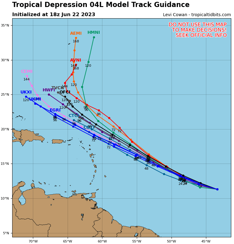
Meanwhile, Tropical Depression Four has developed in the Central Atlantic. As of 11am Thursday, it was centered about 1270 miles east of the Lesser Antilles, moving toward the west-northwest at 15 mph. Maximum sustained winds were near 35 mph. This system should strengthen into Tropical Storm Cindy over the next day or so, and will continue to strengthen through Saturday. However, after that, increasing wind shear will begin to take its toll on this system as well, and it will begin to weak. The track should bring in more toward the northwest with time, meaning it will stay over the open waters of the Central Atlantic, and not impact any land areas.
Thursday night: Becoming mostly cloudy with areas of fog likely, a shower or two is possible. Low 54-61.
Friday: Partly to mostly cloudy, much more humid, chance for a few showers, mainly across the interior. High 74-81.
Friday night: Mostly cloudy, a shower is possible, mainly during the evening. Low 62-69.
Saturday: Partly to mostly cloudy, showers and thunderstorms expected in the afternoon. High 75-82.
Saturday night: Plenty of clouds, a few showers around. Low 62-69.
Sunday: Clouds with some sunny breaks, more showers and thunderstorms possible. High 78-85.
Sunday night: Partly to mostly cloudy, some additional showers likely, especially during the evening. Low 61-68.
Monday: Partly to mostly cloudy with more showers and thunderstorms likely. High 77-84.
